Purbeck Road Ride
13miles
Length
320metres
Elevation gain
1hour 21minutes
Average time
Road
Ride Type
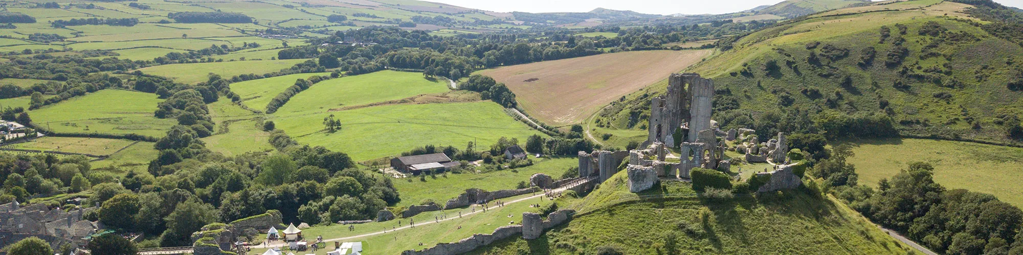
A road ride around the Isle of Purbeck from Swanage via Langton Matravers, Kingston, Corfe Castle and back via the B3351 between Corfe Castle and Studland.
Ride along the top of the Purbeck Hills with stunning views across the Isle of Purbeck, Poole Harbour and the English Channel.
This short but hilly ride takes you through the beautiful Purbeck countryside and past the historic ruins of Corfe Castle.
This ride can be combined with the Corfe and Arne Road Ride to create a 28 mile loop starting from Swanage or Corfe Castle.
Start:
Main Beach Car Park
Victoria Avenue
Swanage
BH19 1PW
OS Grid Ref: SZ 02667 79104
These routes have been recorded using a Garmin GPS unit. We cannot guarantee the accuracy of the available data files due to differences between GPS devices.
Route
Start Victoria Avenue Car Park
Elevation: 8 metres
OS Grid Reference: SZ 02669 79134
Lat, long: 50.61191, -1.96363
Exit the car park and turn left onto Victoria Avenue, follow road over railway bridge and continue along road until you come to a Y junction with signposts for Langton Matravers
Valley Road and Coombe Hill
Elevation: 47 metres
OS Grid Reference: SZ 00755 78854
Lat, long: 50.60940, -1.99069
At Y junction turn left and follow road up through the village of Langton Matravers and along the top of the hill which has views of Corfe Castle and Poole Harbour. Continue to Kingston village.
Kingston Hill and B3069
Elevation: 125 metres
OS Grid Reference: SY 95719 79624
Lat, long: 50.61631, -2.06187
At Kingston village follow road around right hand bend and down Kingston Hill until you reach next T junction at Corfe Castle.
East Street and Valley Road and B3069
Elevation: 37 metres
OS Grid Reference: SY 96447 81098
Lat, long: 50.62957, -2.05159
At junction turn left and follow road through the village of Corfe Castle, continue past right down and around the base of the castle.
A351 and B3351
Elevation: 32 metres
OS Grid Reference: SY 95996 82408
Lat, long: 50.64135, -2.05798
Turn right at second T junction (signpost Studland 5) and go under the railway bridge, follow road until you come to a T junction on your right with a sign for Swanage.
B3351 T junction
Elevation: 114 metres
OS Grid Reference: SZ 01237 81794
Lat, long: 50.63584, -1.98387
Turn right at T junction and follow steep road down to next Y junction.
Junction with Ulwell Road
Elevation: 78 metres
OS Grid Reference: SZ 01812 81219
Lat, long: 50.63066, -1.97574
Turn right onto Ulwell Road and follow road down to Swanage seafront
Shore Road and Victoria Avenue
Elevation: 4 metres
OS Grid Reference: SZ 03073 79141
Lat, long: 50.61198, -1.95793
At junction with Victoria Avenue turn right and follow Victoria Avenue back to start.
Elevation Chart and Map
Move your mouse over the elevation line to view the location on the route map.
Walker & Cyclist Friendly Accommodation
Whether you’re exploring scenic trails, tackling longer routes, or simply enjoying a leisurely ride, choosing the right base makes all the difference. Below you’ll find details of some of the many local accommodation businesses that understands the needs of outdoor enthusiasts, helping you relax, recharge, and get ready for your next journey.