Corfe and Arne Road Ride
15miles
Length
310metres
Elevation gain
1hour 30minutes
Average time
Road
Ride Type
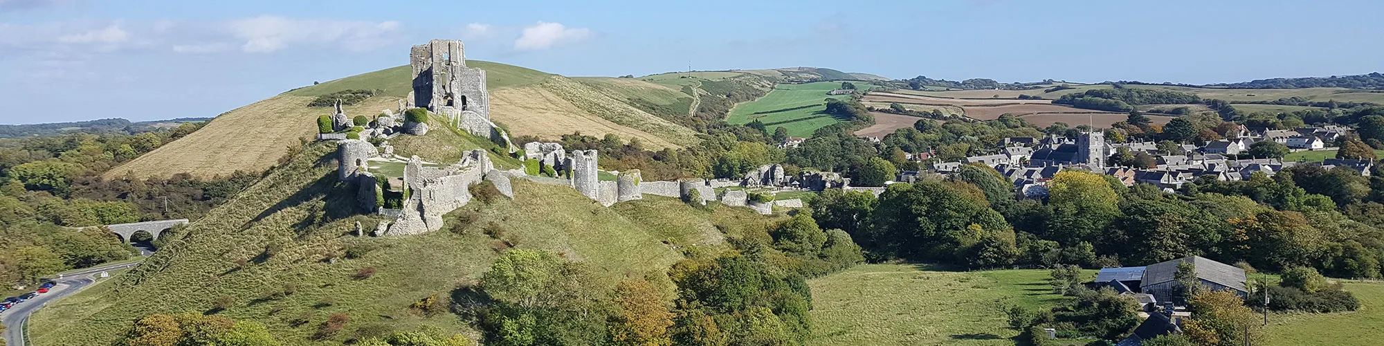
This scenic cycling route takes you on a circuit around the Isle of Purbeck, beginning at the historic village of Corfe Castle. From there, the ride heads towards Creech before looping through Stoborough, then crossing the wide open landscapes of Hartland Moor.
Along the way you’ll encounter a number of steep hills, which provide both a good physical challenge and the reward of panoramic views. From the high points you can enjoy sweeping vistas across the Isle of Purbeck itself and far-reaching views over Poole Harbour.
The mixture of villages, heathland, and open countryside makes this ride a varied and memorable way to experience some of Purbeck’s finest scenery. It’s best suited to cyclists who don’t mind a few climbs in exchange for the chance to take in some truly stunning landscapes.
This ride can be combined with the Purbeck Road Ride to create a 28 mile loop starting from Swanage or Corfe Castle.
Start:
National Trust Car Park, below Corfe Castle
OS Reference: SY 95904 82464
These routes have been recorded using a Garmin GPS unit. We cannot guarantee the accuracy of the available data files due to differences between GPS devices.
Route
Start NT Car Park
Elevation: 23 metres
OS Grid Reference: SY 95902 82454
Lat, long: 50.64176, -2.05931
Start at the National Trust Car Park below Corfe Castle on the A351, exit car park then left then take next right around the back of Corfe Castle. Follow road through Church Knowle until you come to a sharp right corner with Y junction at the top of the hill.
Grange Hill Junction
Elevation: 127 metres
OS Grid Reference: SY 90103 81686
Lat, long: 50.63478, -2.14130
Follow road to the right and along the top of the hill. There is a car park on the right which often has an ice cream van in the summer. Continue along the road and down steep hill through the trees.
T junction
Elevation: 64 metres
OS Grid Reference: SY 91724 83437
Lat, long: 50.65056, -2.11843
At second T junction on your right signpost Creech 1 turn right and follow road through Creech and past the duck pond.
T Junction
Elevation: 79 metres
OS Grid Reference: SY 93249 82547
Lat, long: 50.64257, -2.09684
Turn left at junction and follow road until you come to roundabout.
Roundabout
Elevation: 24 metres
OS Grid Reference: SY 92843 85349
Lat, long: 50.66776, -2.10263
At roundabout go straight across following sign for Arne
Junction Corfe Road and New Road
Elevation: 13 metres
OS Grid Reference: SY 92652 85722
Lat, long: 50.67111, -2.10534
Turn right onto New Road and follow road past houses until cross roads.
Cross Roads
Elevation: 12 metres
OS Grid Reference: SY 93146 86189
Lat, long: 50.67532, -2.09837
At cross roads turn right and follow road towards Arne until second junction signposted Corfe Castle 3
Junction
Elevation: 6 metres
OS Grid Reference: SY 95487 86530
Lat, long: 50.67841, -2.06524
Turn right at junction and follow road across the heathland over 2 cattle grids until you come to a T junction past railway bridge.
T junction
Elevation: 29 metres
OS Grid Reference: SY 95484 82867
Lat, long: 50.64547, -2.06524
Turn right at junction and then left at roundabout and follow road back to Corfe Castle and start.
Elevation Chart and Map
Move your mouse over the elevation line to view the location on the route map.
Walker & Cyclist Friendly Accommodation
Whether you’re exploring scenic trails, tackling longer routes, or simply enjoying a leisurely ride, choosing the right base makes all the difference. Below you’ll find details of some of the many local accommodation businesses that understands the needs of outdoor enthusiasts, helping you relax, recharge, and get ready for your next journey.