The Obelisk Walk
5miles
Length
170metres
Elevation gain
34minutes
Average time
Walk
Ride Type
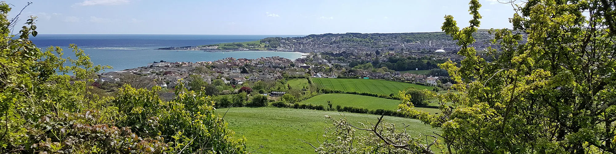
This hilly walk starting in central Swanage takes you across open fields before a steep climb to the stone obelisk on the Purbeck Hills, following the ridgeline east before descending to Swanage beach and following the shoreline back to the start.
A walk with steep hills and stunning views over Swanage, Studland and Poole Harbour from the Purbeck Hills.
Start:
Main Beach Car Park
Victoria Avenue
Swanage
BH19 1PW
OS Grid Ref: SZ 02667 79104
These routes have been recorded using a Garmin GPS unit. We cannot guarantee the accuracy of the available data files due to differences between GPS devices.
Route
Start of walk
Elevation: 3 metres
OS Grid Reference: SZ 02678 79104
Lat, long: 50.61164, -1.96351
Start from the Car park in Victoria Avenue, exit the car park and turn left onto Victoria Avenue and continue along Victoria Avenue past two T junctions.
T Junction
Elevation: 4 metres
OS Grid Reference: SZ 02134 79290
Lat, long: 50.61332, -1.97121
Turn right at junction and go past farm building.
Junction with narrow road.
Elevation: 5 metres
OS Grid Reference: SZ 02096 79335
Lat, long: 50.61372, -1.97173
Turn right and follow narrow road north and towards the Purbeck Hills.
Stile
Elevation: 13 metres
OS Grid Reference: SZ 02102 79610
Lat, long: 50.61620, -1.97165
At stile on left side, go over stile and follow path across open field to your right over next stile and then through bushes to small bridge.
Bridge
Elevation: 11 metres
OS Grid Reference: SZ 02001 79761
Lat, long: 50.61756, -1.97307
Cross the bridge and continue north across the field.
T junction
Elevation: 23 metres
OS Grid Reference: SZ 02099 80266
Lat, long: 50.62210, -1.97169
At the T Junction go straight ahead past the brick works and continue up the hill until you reach Ulwell Road junction.
T Junction
Elevation: 40 metres
OS Grid Reference: SZ 02223 80823
Lat, long: 50.62710, -1.96994
Go across Ulwell Road and left into layby on the right side of the road next to small stream.
Metal Swing Gate
Elevation: 44 metres
OS Grid Reference: SZ 02154 80926
Lat, long: 50.62803, -1.97091
At the metal swing gate go though the gate and follow path up the hill.
Start of steep climb
Elevation: 61 metres
OS Grid Reference: SZ 02135 81023
Lat, long: 50.62890, -1.97117
At cross roads in paths continue straight ahead and go up steep hill until you reach the stile at the top.
The Obelisk
Elevation: 151 metres
OS Grid Reference: SZ 02231 81298
Lat, long: 50.63138, -1.96982
At the Obelisk turn right and follow the track up the hill until you reach the next wooden gate.
Wooden Gate
Elevation: 169 metres
OS Grid Reference: SZ 02523 81272
Lat, long: 50.63114, -1.96569
At the wooden gate continue straight ahead along the top of the Purbeck Hills.
Gate and earth mounds
Elevation: 136 metres
OS Grid Reference: SZ 03974 81308
Lat, long: 50.63146, -1.94518
When you come to a gate with large earth mounds to the right, turn right and follow narrow path down the hill.
Stile
Elevation: 120 metres
OS Grid Reference: SZ 03969 81216
Lat, long: 50.63063, -1.94525
Go over the stile and follow path down the side of the hill until you come to the lower track, turn left and follow the track down to another stile.
Stile
Elevation: 65 metres
OS Grid Reference: SZ 03819 81062
Lat, long: 50.62925, -1.94736
Go over the stile and follow the narrow path down the edge of the fields until you come to stone steps.
Stone Steps
Elevation: 21 metres
OS Grid Reference: SZ 03403 80421
Lat, long: 50.62348, -1.95325
At the stone steps you can either go straight ahead and up second set of steps to return to Swanage via Ulwell Road and the sea front or turn left and follow path and wooden steps down to the beach, turning right at the bottom and following beach back towards the town.
Victoria Avenue Junction
Elevation: 8 metres
OS Grid Reference: SZ 03087 79152
Lat, long: 50.61207, -1.95773
At T junction with Victoria Avenue, turn left and follow road back to car park and the start of walk.
Elevation Chart and Map
Move your mouse over the elevation line to view the location on the route map.
Walker & Cyclist Friendly Accommodation
Whether you’re exploring scenic trails, tackling longer routes, or simply enjoying a leisurely ride, choosing the right base makes all the difference. Below you’ll find details of some of the many local accommodation businesses that understands the needs of outdoor enthusiasts, helping you relax, recharge, and get ready for your next journey.