South West Coast Path Swanage to Sandbanks Ferry
7.6miles
Length
140metres
Elevation gain
45minutes
Average time
Walk
Ride Type
A 7.6 mile point to point walk from Swanage, heading onto the Purbeck Hills, past Old Harry Rocks to Studland and walking the entire length of Studland Beach to the chain ferry.
The route can be reversed by taking the Bus from Swanage to Bournemouth and disembarking before the ferry. Approx location OS Grid Ref: SZ 03588 86558.
There is a hourly bus service from Bournemouth to Swanage which stops at the ferry to pick you up and return you to Swanage at the end of your walk.
Start:
Swanage Station
Station Approach
Swanage
BH19 1HB
OS Grid Ref: SZ 02936 78899
These routes have been recorded using a Garmin GPS unit. We cannot guarantee the accuracy of the available data files due to differences between GPS devices.
Route
Start at Swanage Bus Station
Elevation: 3 metres
OS Grid Reference: SZ 02929 78901
Lat, long: 50.60982, -1.95997
From Swanage Bus station, walk East to Station Road and follow Station Road to the junction with Shore Road.
Shore Road Junction
Elevation: 5 metres
OS Grid Reference: SZ 03108 78846
Lat, long: 50.60932, -1.95744
At the junction with Shore Road, turn left and follow Shore Road until the road turns away from the beach onto Ulwell Road
Ulwell Road
Elevation: 25 metres
OS Grid Reference: SZ 03096 79641
Lat, long: 50.61647, -1.95760
Continue up along Ulwell Road until you come to a junction on your right for Ballard Way and a shop on the corner.
Ballard Way Junction
Elevation: 23 metres
OS Grid Reference: SZ 02971 80252
Lat, long: 50.62196, -1.95937
At the junction with Ballard Way, turn right and continue to Ballard Estate following footpath signs.
Junction
Elevation: 25 metres
OS Grid Reference: SZ 03258 80227
Lat, long: 50.62174, -1.95530
Turn left at the junction and continue until you come to the footpath on the right side
Start of Footpath
Elevation: 25 metres
OS Grid Reference: SZ 03284 80315
Lat, long: 50.62253, -1.95494
Turn right and follow the footpath past the buildings and left across an open field to concrete steps.
Steps and Footpaths
Elevation: 16 metres
OS Grid Reference: SZ 03400 80420
Lat, long: 50.62348, -1.95330
Go down the steps and continue straight ahead up smaller steps to the coast path. Follow the twisting path along the top of the cliff until you come to a gate.
Gate and Steps
Elevation: 60 metres
OS Grid Reference: SZ 03819 81061
Lat, long: 50.62923, -1.94737
Go through the gate and continue straight ahead up steps and when the path splits, continue to the right up the hill to the top following the narrow path.
Bridleway and Purbeck Way
Elevation: 104 metres
OS Grid Reference: SZ 03999 81318
Lat, long: 50.63154, -1.94482
At the top of the hill, turn right and continue along the ridge line following a well used path though a wooden gate to a narrow chalk path
Chalk narrow path and field
Elevation: 109 metres
OS Grid Reference: SZ 04417 81340
Lat, long: 50.63174, -1.93892
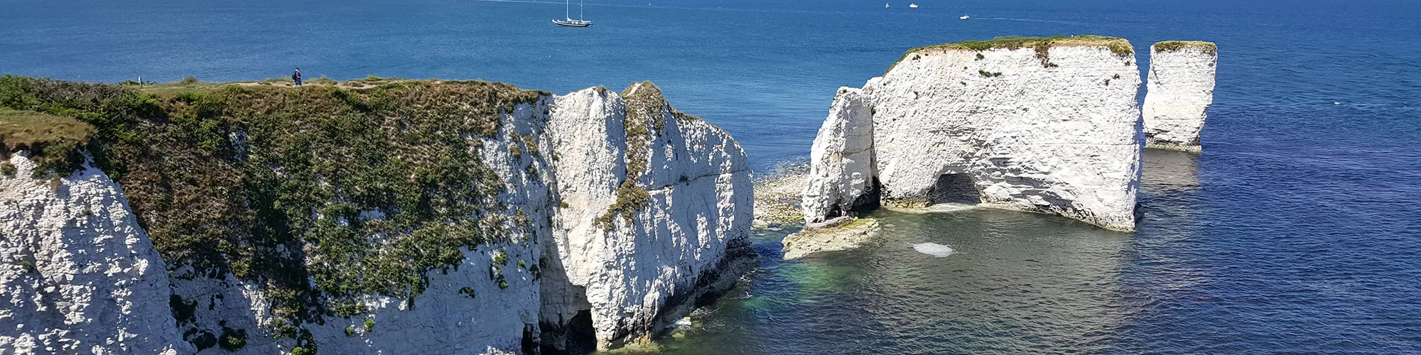
Continue though the narrow chalk path section and turn to your right following the rough track to a second gate, continue though the gate and follow the coast path along the top of the cliffs down the hill then left to the Foreland and Old Harry Rocks.
The Foreland and Old Harry Rocks
Elevation: 20 metres
OS Grid Reference: SZ 05435 82462
Lat, long: 50.64182, -1.92450
At the Foreland turn left and follow the wide track heading West to Studland.
Junction Manor Road and Watery Lane
Elevation: 22 metres
OS Grid Reference: SZ 03865 82422
Lat, long: 50.64148, -1.94670
At the junction with Manor Road and Watery Lane, turn right and continue up the hill past the pub until you come to a footpath on the right side.
Footpath to Fort Henry
Elevation: 28 metres
OS Grid Reference: SZ 03775 82550
Lat, long: 50.64263, -1.94798
Turn right and follow the footpath heading East then turning North past Fort Henry to the Middle Beach Car Park entrance.
Middle Beach Car Park
Elevation: 22 metres
OS Grid Reference: SZ 03622 82811
Lat, long: 50.64498, -1.95014
At the end of the footpath, turn right and follow the road down to the beach. At high tide you will have to go though the car park and use the path at the end to access the beach.Turn left onto Studland Beach.
Studland Beach
Elevation: 7 metres
OS Grid Reference: SZ 03658 82914
Lat, long: 50.64590, -1.94962
Turn left onto the beach and walk along the shoreline heading North along the South West Coast Path until you reach the Chain Ferry.
Ferry Road and Bus Stop
Elevation: 3 metres
OS Grid Reference: SZ 03615 86648
Lat, long: 50.67948, -1.95020
At the end of the beach you will find the bus stop which takes you back to Swanage and a cafe on the harbour side for a refreshing drink and meal.
Elevation Chart and Map
Move your mouse over the elevation line to view the location on the route map.
Walker & Cyclist Friendly Accommodation
Whether you’re exploring scenic trails, tackling longer routes, or simply enjoying a leisurely ride, choosing the right base makes all the difference. Below you’ll find details of some of the many local accommodation businesses that understands the needs of outdoor enthusiasts, helping you relax, recharge, and get ready for your next journey.