Durlston to Dancing Ledge Walk
5.75miles
Length
170metres
Elevation gain
37minutes
Average time
Walk
Ride Type
This is a 5.75 mile walk from Durlston Country Park to Dancing Ledge following the upper path on the cliffs and Jurassic Coast and returns via Priests Way and Townsend nature reserve.
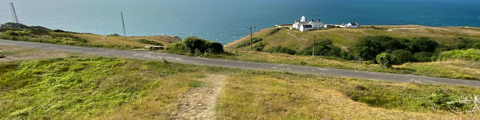
The walk offers stunning views over the Isle of Purbeck and the Jurassic Coast.
Start:
Durlston Country Park Car Park
OS Reference: SZ 03225 77353
These routes have been recorded using a Garmin GPS unit. We cannot guarantee the accuracy of the available data files due to differences between GPS devices.
Route
Lighthouse Road Car Park
Elevation: 66 metres
OS Grid Reference: SZ 03282 77317
Lat, long: 50.59557, -1.95499
Start in the Car Park at the end of Lighthouse road and exit the car park heading South and then turn right onto a tarmac path / road heading West until you come to an area with dry stone walls on your right and a gateway ahead where the road bears left and down.
Lighthouse service road and path
Elevation: 79 metres
OS Grid Reference: SZ 03080 77204
Lat, long: 50.59455, -1.95784
At the gateway continue straight ahead along a well used path in the grass and continue West to the next wide gate with a kissing gate alongside.
Kissing Gate
Elevation: 77 metres
OS Grid Reference: SZ 02748 77202
Lat, long: 50.59454, -1.96254
Continue straight ahead at the gate as the track goes down a slight incline to the next gate with a small wooden bridge on your left.
Wooden Bridge
Elevation: 81 metres
OS Grid Reference: SZ 02564 77168
Lat, long: 50.59423, -1.96514
Turn left and go across the small bridge and follow the narrow track up the hill heading South. At the top of the hill turn right and follow the track to the next wall and stile.
Wall and Stile
Elevation: 71 metres
OS Grid Reference: SZ 02569 77073
Lat, long: 50.59338, -1.96507
Go over the stile and follow the track heading West along the top of the ridgeline to the next wall and stile. There are some rocky sections on this track so take care.
Wall and Stile
Elevation: 82 metres
OS Grid Reference: SZ 02297 77019
Lat, long: 50.59290, -1.96890
Go over the stile and follow the track heading West along the top of the ridgeline to the next wall and stile
Wall and Stile
Elevation: 88 metres
OS Grid Reference: SZ 02028 77036
Lat, long: 50.59305, -1.97271
Go over the stile and the track splits with the lower track heading down the side of the hill and the upper track following the ridgeline, Continue along the upper track to a wide gap in the next wall. This can be muddy in winter.
Wall and wide entranceway
Elevation: 88 metres
OS Grid Reference: SZ 01786 77079
Lat, long: 50.59344, -1.97612
Go through the wide entrance in the stone wall heading West and continue down a small slope then turn right up a wide track to the stone wall on your right. This section can be muddy in winter.
Open Field and junction to Belle vue farm and Quarries
Elevation: 86 metres
OS Grid Reference: SZ 01572 77076
Lat, long: 50.59341, -1.97915
At the edge of the open field, continue heading North-West along the field to the next wall.
Wall and Stile
Elevation: 116 metres
OS Grid Reference: SZ 01388 77115
Lat, long: 50.59376, -1.98174
Go over the stile and continue along the field heading West to the next gateway with a stile alongside.
Gateway and Stile
Elevation: 119 metres
OS Grid Reference: SZ 01205 77115
Lat, long: 50.59376, -1.98434
Go over the stile and follow the path heading West to the next wall with a small kissing gate
Wall and Stile
Elevation: 88 metres
OS Grid Reference: SZ 00925 77112
Lat, long: 50.59374, -1.98829
Continue over the stile and follow the narrow rocky path heading West. This section is narrow and very rocky in some sections and can be muddy in winter. Continue heading West along this track until you come to a kissing gate and open field on your right side.
Kissing Gate and open field
Elevation: 79 metres
OS Grid Reference: SZ 00309 77098
Lat, long: 50.59361, -1.99700
At the kissing gate, go though the gate and walk North-West across the field with bushes on your left. After approx 90m you will see a path heading down to your left between the bushes, Turn left and follow the track across to a stile and gap in the wall ahead.
Stile and Wall
Elevation: 99 metres
OS Grid Reference: SZ 00170 77198
Lat, long: 50.59451, -1.99895
Continue across the next field following a well used path to the next stone wall and stile/gap.
Wall and Gap to Dancing Ledge
Elevation: 101 metres
OS Grid Reference: SY 99965 77150
Lat, long: 50.59408, -2.00186
At the next wall / track gap turn slightly right and follow the track heading up a slight slope until you come to a kissing gate on your right in the stone wall. This is the top of Dancing Ledge, If you wish you can follow the well used path down the valley on your left to Dancing Ledge or have a rest on the stone bench at the top and enjoy the view.
Kissing Gate and Wall
Elevation: 101 metres
OS Grid Reference: SY 99876 77198
Lat, long: 50.59451, -2.00312
Go though the kissing gate and continue heading North across the field following a wide track to the next wall and gap. Continue across the second field to the farm buildings and gate.
Spyway Farm Gate
Elevation: 118 metres
OS Grid Reference: SY 99914 77670
Lat, long: 50.59876, -2.00258
Go though the gate into the farm yard and continue past the farm buildings until the track splits left and right.
Track Junction
Elevation: 118 metres
OS Grid Reference: SY 99906 77732
Lat, long: 50.59932, -2.00269
At the Y junction in the track turn right and follow the track down to the Priests Way and gateway.
Priests Way Gateway
Elevation: 111 metres
OS Grid Reference: SZ 00014 77835
Lat, long: 50.60024, -2.00116
At the gateway continue straight ahead heading East following the wide track down until the track turns left with farm buildings on your left side. Continue along the wide track following the Priests Way and left down the hill heading North until you come to a wide gate with a Y junction on the other side.
Gate and Y Junction
Elevation: 87 metres
OS Grid Reference: SZ 00741 78126
Lat, long: 50.60286, -1.99089
Go though the gate and then turn right onto the wide track and follow the track heading East going past farm buildings until you come to a wide gate.
Gate
Elevation: 88 metres
OS Grid Reference: SZ 00960 78172
Lat, long: 50.60326, -1.98780
Go though the gate and continue heading East to the next metal gate
Metal Gate
Elevation: 90 metres
OS Grid Reference: SZ 01019 78181
Lat, long: 50.60335, -1.98696
Go though the metal gate and continue along the Priests Way to the next metal gate.
Metal Gate
Elevation: 95 metres
OS Grid Reference: SZ 01475 78242
Lat, long: 50.60390, -1.98051
Go though the metal gate and continue along the Priests Way to the next junction with a wide track on your right and narrower track with a wooden sign on your left.
Junction
Elevation: 95 metres
OS Grid Reference: SZ 01540 78250
Lat, long: 50.60397, -1.97960
At the junction turn left then turn right onto a narrow grass path which heads South with a stone building on your right and then turns left and East onto a narrow path with a fence on both sides. Continue along this path to the next metal kissing gate.
Metal Kissing Gate
Elevation: 97 metres
OS Grid Reference: SZ 01759 78251
Lat, long: 50.60398, -1.97651
Continue though the metal kissing gate and follow the narrow path to a rough road, Turn left and go down the hill until you come to a wide track on your right with a building on the left side.Turn right and follow this path East to the next narrow entrance and tarmac road. This section is used for camping in the summer months and often has tents across the path.
Road and Caravan Park
OS Grid Reference: SZ 01986 78298
Lat, long: 50.60440, -1.97329
At the caravan park turn left and follow the steep road down to a lifting entrance gate and the park reception area. Go though the side of the lifting gate to the road and parking area below.
Park entrance and road
OS Grid Reference: SZ 02012 78513
Lat, long: 50.60633, -1.97293
Turn right at the road and continue straight ahead at the next junction following the road as it turns right up a steep hill. After approx 100m on the hill turn left into a narrow entrance on your left into the Townsend Nature Reserve
Panorama Road Townsend Nature Reserve
OS Grid Reference: SZ 02225 78387
Lat, long: 50.60519, -1.96992
Turn left into the Townsend Nature Reserve and follow the path heading South-East across the nature reserve, going past old quarry works and continue across the field until you come to a kissing gate onto Townsend Road.
Gate and Townsend Road
OS Grid Reference: SZ 02632 78263
Lat, long: 50.60408, -1.96417
At Townsend Road, turn right and follow the road up the hill until you come to a Y junction with the tarmac road heading right and a rough track straight ahead. Continue down the hill to a wide metal gate a continue up the next field to a narrow kissing gate. Continue along the next field until you come to a gate on your left with a gate straight ahead and also a path on your right.
Gates and cross roads
OS Grid Reference: SZ 02703 77423
Lat, long: 50.59653, -1.96316
Turn left though the wooden gate and continue heading East across the field to the next gate.
Gate and Field entrance
OS Grid Reference: SZ 02895 77430
Lat, long: 50.59658, -1.96046
Continue straight ahead at the gate and follow the path across the field to another wooden gate
Wooden Gate
OS Grid Reference: SZ 03052 77366
Lat, long: 50.59601, -1.95824
At the gate go straight ahead and then turn right and follow the path past the Durlston Country Park buildings and into the car park.
Durlston Country Park Buildings
OS Grid Reference: SZ 03146 77335
Lat, long: 50.59573, -1.95692
Continue East across the car park and cross Durlston Road and then turn right back to the Lighthouse Road Car Park and start of the route.
Elevation Chart and Map
Move your mouse over the elevation line to view the location on the route map.
Walker & Cyclist Friendly Accommodation
Whether you’re exploring scenic trails, tackling longer routes, or simply enjoying a leisurely ride, choosing the right base makes all the difference. Below you’ll find details of some of the many local accommodation businesses that understands the needs of outdoor enthusiasts, helping you relax, recharge, and get ready for your next journey.