Rempstone Long
10miles
Length
200metres
Elevation gain
1hour 25minutes
Average time
Off Road
Ride Type
Starting on the Studland Ferry Road, this is a short off-road ride takes you around Rempstone Forest.
The ride begins with a two mile climb on loose tracks followed by a two mile decent on twisting and technical single-track.
Follow smooth forest tracks through Rempstone Forest and finish the ride around the edge of Poole Harbour.
Parking is available in National Trust car parks near the ferry and in Studland village.
Start:
Start on the Ferry Road between the Sandbanks Ferry and Studland village on corner with bus stop on Poole Harbour side
OS Grid Ref: SZ 0255384337 N50 39.522 W1 57.915
These routes have been recorded using a Garmin GPS unit. We cannot guarantee the accuracy of the available data files due to differences between GPS devices.
Route
Start of ride
Elevation: 23 metres
OS Grid Reference: SZ 02552 84337
Lat, long: 50.65870, -1.96526
Start on the Ferry Road between the Sandbanks Ferry and Studland village on corner with bus stop on Poole Harbour side. SZ 0255384337 N50 39.522 W1 57.915Parking spaces are available on the side of the road and in the National Trust car parks in Studland or next to the chain ferry. Go through the small gate on the left side of the rough track and follow the rough track up and across the heathland with Agglestone rock ahead.
Y Junction
Elevation: 46 metres
OS Grid Reference: SZ 02476 83334
Lat, long: 50.64969, -1.96635
Go straight ahead and follow rough track across the heathland which bears right.
Crossroads
Elevation: 47 metres
OS Grid Reference: SZ 02454 83276
Lat, long: 50.64917, -1.96666
Go across the track and follow rough track across the heathland which bears right.
T Junction
Elevation: 89 metres
OS Grid Reference: SZ 01928 82495
Lat, long: 50.64214, -1.97409
Turn left and follow track up slope to T Junction with double wooden gate on your right.
T Junction and Gates
Elevation: 95 metres
OS Grid Reference: SZ 02085 82453
Lat, long: 50.64176, -1.97187
Turn right at the junction and go through the double wooden gates and follow the narrow bridleway up the hill towards the golf course.
Junction
Elevation: 116 metres
OS Grid Reference: SZ 01869 82183
Lat, long: 50.63934, -1.97494
Turn right following bridleway signs until you come to a T junction on your right with a stone marker sign on the right side.
T junction
Elevation: 123 metres
OS Grid Reference: SZ 01783 82101
Lat, long: 50.63860, -1.97615
Turn right and follow narrow singletrack down across the heathland
T Junction
Elevation: 118 metres
OS Grid Reference: SZ 01689 82112
Lat, long: 50.63869, -1.97748
Go straight ahead at T junction and follow the narrow singletrack to the left down across the heathland with the golf course to your left side. The track can be muddy in winter and has a lot of tight twisting turns and technical sections.
Golf course road
Elevation: 111 metres
OS Grid Reference: SZ 01448 82037
Lat, long: 50.63802, -1.98088
Go straight ahead at the small cross roads onto the narrow track and continue along the narrow singletrack down across the heathland.
Bridleway Split
Elevation: 88 metres
OS Grid Reference: SZ 01038 82575
Lat, long: 50.64286, -1.98669
Take the left side of the bridleway when it splits into two tracks.
Bridleway Junction
Elevation: 75 metres
OS Grid Reference: SZ 00866 82784
Lat, long: 50.64474, -1.98911
Continue on the left track at Y junction on the bridleway.
Wooden Gate
Elevation: 66 metres
OS Grid Reference: SZ 00558 82807
Lat, long: 50.64495, -1.99347
Go straight ahead at the wooden gate and continue to next gate.
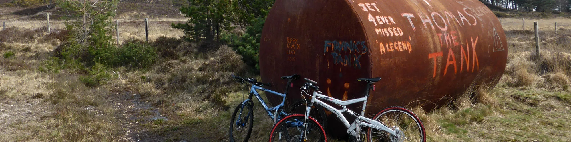
Gate and Franks Tank
Elevation: 63 metres
OS Grid Reference: SZ 00448 82835
Lat, long: 50.64520, -1.99503
Go through the gate next to a large metal tank with Franks Tank painted on the end and follow the track straight ahead along the edge of the trees until you come the second T junction with a track on your right with a bridleway sign.
T Junction
Elevation: 47 metres
OS Grid Reference: SY 99875 83035
Lat, long: 50.64700, -2.00314
Turn right and follow the bridleway track along a straight level track until you come to a cross roads with a tarmac road.
Cross Roads
Elevation: 33 metres
OS Grid Reference: SZ 00147 84474
Lat, long: 50.65994, -1.99928
Go through the gate and turn left onto the tarmac road. Continue along the road until you come to a cross roads with a rough track straight ahead.
Cross Roads
Elevation: 30 metres
OS Grid Reference: SY 99414 84046
Lat, long: 50.65609, -2.00965
Continue straight ahead onto the rough track and follow the track until you come to a metal gate.
Metal Gate
Elevation: 40 metres
OS Grid Reference: SY 98091 83532
Lat, long: 50.65147, -2.02836
Continue straight ahead at the gate and follow the track until you come to a T junction with a tarmac road.
Road Junction
Elevation: 34 metres
OS Grid Reference: SY 97659 83531
Lat, long: 50.65146, -2.03447
Turn right onto the road and continue until next junction on your right.
T Junction
Elevation: 28 metres
OS Grid Reference: SY 97781 83793
Lat, long: 50.65381, -2.03275
Turn right and follow the road past the farm and houses until you come to a metal gate straight ahead.
Metal Gate
Elevation: 26 metres
OS Grid Reference: SY 98197 83988
Lat, long: 50.65557, -2.02687
Continue straight ahead at the metal gate onto forest track.
T Junction
Elevation: 24 metres
OS Grid Reference: SY 98387 84104
Lat, long: 50.65661, -2.02417
Continue straight ahead at the T junction and follow sandy and gravel track though the forest until you come to a cross roads with a tarmac road.
Cross Road
Elevation: 21 metres
OS Grid Reference: SY 99241 84779
Lat, long: 50.66269, -2.01209
Continue straight across the road onto the forest track and follow the track until you come to a T junction with a gate on the right side.
T junction
Elevation: 14 metres
OS Grid Reference: SY 99718 85282
Lat, long: 50.66720, -2.00535
Continue straight ahead up small slope until you come to a gate on the right side.
Wooden Gate
Elevation: 20 metres
OS Grid Reference: SY 99781 85337
Lat, long: 50.66770, -2.00446
Turn right and go through the gate and then left following the track across the field. The track follows the edge of the field until you come to a gate next to a cottage and trees.
Gate and Cottage
Elevation: 13 metres
OS Grid Reference: SZ 00411 85022
Lat, long: 50.66487, -1.99555
Go through the gate and turn left and follow track to next T Junction.
T Junction
Elevation: 13 metres
OS Grid Reference: SZ 00519 85023
Lat, long: 50.66488, -1.99402
Turn right at the junction and follow the track up a small hill to the tarmac road.
T Junction and Road
Elevation: 24 metres
OS Grid Reference: SZ 00822 84865
Lat, long: 50.66345, -1.98973
Turn left onto the tarmac road and continue along the road until you come to a Y junction with a rough track on the right side.
Y Junction
Elevation: 21 metres
OS Grid Reference: SZ 01066 84867
Lat, long: 50.66348, -1.98628
Turn right at the T junction and follow the rough track down a small hill and along the edge of the forest.
Gate
Elevation: 11 metres
OS Grid Reference: SZ 01598 84522
Lat, long: 50.66037, -1.97876
Continue straight ahead at the gate and down hill over a small bridge and follow the track up the hill until you come to a T junction with a gate on the right side.
T Junction
Elevation: 11 metres
OS Grid Reference: SZ 01828 84497
Lat, long: 50.66015, -1.97550
Turn left at the T junction and follow the track back to the Ferry road and start of the ride.
Elevation Chart and Map
Move your mouse over the elevation line to view the location on the route map.
Walker & Cyclist Friendly Accommodation
Whether you’re exploring scenic trails, tackling longer routes, or simply enjoying a leisurely ride, choosing the right base makes all the difference. Below you’ll find details of some of the many local accommodation businesses that understands the needs of outdoor enthusiasts, helping you relax, recharge, and get ready for your next journey.