Kimmeridge Ride
22miles
Length
510metres
Elevation gain
3hours 10minutes
Average time
Off Road
Ride Type
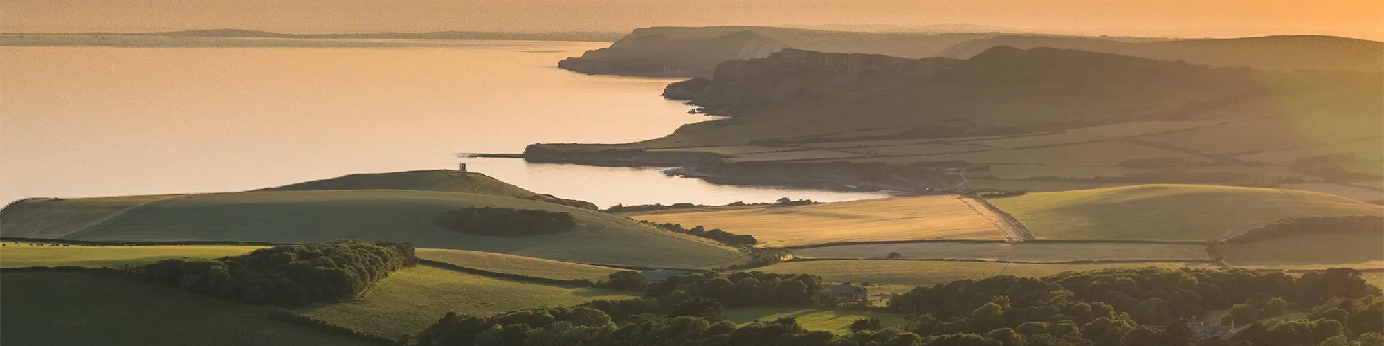
This challenging and rewarding loop starts in Swanage before heading west towards the hills above Kimmeridge and along the ridge of the Purbeck Hills. The ride offers a mix of demanding terrain, with tough climbs that test your stamina, followed by fast downhill sections that deliver an exhilarating rush.
The return leg takes you back towards Swanage through the peaceful tracks of Rempstone Forest, near Studland. Here, the route becomes more open, with stretches of gravel-track and sandy sections that require confident bike handling skills.
The variety of landscapes, from open hills to forest trails, makes this loop both exciting and memorable. However, the tracks can become muddy and slippery in winter, so a suitable bike and tyres are essential. This ride is best suited to experienced cyclists looking for a mix of challenge, speed and technical riding in the heart of Purbeck.
Start:
Main Beach Car Park
Victoria Avenue
Swanage
BH19 1PW
OS Grid Ref: SZ 02667 79104
These routes have been recorded using a Garmin GPS unit. We cannot guarantee the accuracy of the available data files due to differences between GPS devices.
Route
Car Park
Elevation: 8 metres
OS Grid Reference: SZ 02676 79130
Lat, long: 50.61188, -1.96354
Start at Victoria Avenue car park, exit car park and turn left along Victoria Avenue
Junction to Langton
Elevation: 47 metres
OS Grid Reference: SZ 00735 78880
Lat, long: 50.60964, -1.99097
Turn Left at junction to Langton Matravers and continue up hill and follow signs for Kingston
Kingston Village
Elevation: 125 metres
OS Grid Reference: SY 95719 79624
Lat, long: 50.61631, -2.06187
At Kingston village, continue straight ahead past pub and up hill with church on your left, continue along road past car park into open countryside until you come to a small car park on your left
Car Park
Elevation: 145 metres
OS Grid Reference: SY 94312 79258
Lat, long: 50.61301, -2.08176
At car park turn left and then straight ahead up and across field on wide track and through gates, continue along track until you come to Swyre Head
Swyre Head
Elevation: 169 metres
OS Grid Reference: SY 93353 78593
Lat, long: 50.60701, -2.09530
At Swyre Head turn right and follow track along top of hill, through several gates until you come to a road.
Junction
Elevation: 115 metres
OS Grid Reference: SY 91907 80098
Lat, long: 50.62053, -2.11576
At road, turn right and continue along road past a farmhouse
Junction
Elevation: 68 metres
OS Grid Reference: SY 93540 80626
Lat, long: 50.62530, -2.09268
At junction left and continue along road
Cross Road
Elevation: 56 metres
OS Grid Reference: SY 93411 81667
Lat, long: 50.63466, -2.09453
At cross roads, continue straight ahead for and up steep hill, continue up and over hill and look for the bridleway signposts and small parking area on your right past the campsite.
Bridleway
Elevation: 68 metres
OS Grid Reference: SY 93270 82847
Lat, long: 50.64527, -2.09654
At sharp left corner, turn right onto singletrack and follow bridleway signs along singletrack until you come to the Norden Farm camp site.
Norden Farm
Elevation: 45 metres
OS Grid Reference: SY 94745 82912
Lat, long: 50.64587, -2.07569
Continue past campsite area, through farm yard and follow road to main road.
A351 Junction
Elevation: 33 metres
OS Grid Reference: SY 95245 82900
Lat, long: 50.64577, -2.06862
At main road turn left, be careful on this road as the traffic is often very heavy, continue along road until you come to red brick houses with a farm track on your right
A351 and Gallows Hill and New Line
Elevation: 34 metres
OS Grid Reference: SY 94536 83452
Lat, long: 50.65073, -2.07865
Turn right along track and follow bridleway signs
Farm Track
Elevation: 19 metres
OS Grid Reference: SY 95164 83658
Lat, long: 50.65258, -2.06977
Turn right along track over several cattle grids and left when you come to tarmac road, continue along road for approx 1 mile until you come to a gate with bridleway sign on your right
Rempstone Forest
Elevation: 5 metres
OS Grid Reference: SY 96396 84930
Lat, long: 50.66403, -2.05236
At gate continue straight ahead thought next gate and over small stone bridge, then right to large open field on track.
Metal gate
Elevation: 6 metres
OS Grid Reference: SY 96689 84755
Lat, long: 50.66246, -2.04820
Follow track across field and through next gate until you come to road
Cross Roads
Elevation: 22 metres
OS Grid Reference: SY 97113 84400
Lat, long: 50.65927, -2.04221
At road cross to track and follow track through trees on forest track until you come to road.
Junction
Elevation: 19 metres
OS Grid Reference: SY 97353 84096
Lat, long: 50.65653, -2.03881
Continue straight ahead on road marked “Bridleway Only” and follow road until you come to a turning on your left with a large power transformer on left side
Junction
Elevation: 28 metres
OS Grid Reference: SY 97652 83530
Lat, long: 50.65145, -2.03458
Turn left onto well defined track and continue straight ahead, this track can be muddy in winter, at junction with road, continue straight ahead for approx 100m
Gate
Elevation: 33 metres
OS Grid Reference: SY 99624 84073
Lat, long: 50.65633, -2.00668
Turn right and go through gate and follow track as it bears right then left and past campsite on your right
T Junction
Elevation: 40 metres
OS Grid Reference: SY 99802 83031
Lat, long: 50.64696, -2.00416
At T-junction on track, turn left and straight ahead until you come to a large metal tank with “Franks Tank” written on side
Franks Tank
Elevation: 56 metres
OS Grid Reference: SZ 00451 82843
Lat, long: 50.64527, -1.99499
At Franks Tank, go straight ahead through gate and follow signposted bridleway along the side of the golf course until you come to a T-junction
T Junction
Elevation: 105 metres
OS Grid Reference: SZ 01784 82104
Lat, long: 50.63862, -1.97613
At T-junction turn right and continue along track until you come to road, caution busy road in summer months
B3351 Gate
Elevation: 110 metres
OS Grid Reference: SZ 01715 81870
Lat, long: 50.63652, -1.97711
At road turn right and continue past golf course entrance on your right, take next left road junction
T Junction
Elevation: 114 metres
OS Grid Reference: SZ 01237 81794
Lat, long: 50.63584, -1.98387
Turn left and follow road down hill.
Junction
Elevation: 78 metres
OS Grid Reference: SZ 01812 81219
Lat, long: 50.63066, -1.97574
Turn right at bottom of hill and onto main road, caution can be very busy in summer, continue down Ulwell Road and past Welcome to Swanage sign.
Ulwell Road and Darkie Lane
Elevation: 49 metres
OS Grid Reference: SZ 02231 80818
Lat, long: 50.62706, -1.96981
Right at Ulwell Cottage caravan site and bear left down hill on Darkie Lane to Northbrook Road, straight ahead at roundabout and follow Northbrook Road back to start point.
Elevation Chart and Map
Move your mouse over the elevation line to view the location on the route map.
Walker & Cyclist Friendly Accommodation
Whether you’re exploring scenic trails, tackling longer routes, or simply enjoying a leisurely ride, choosing the right base makes all the difference. Below you’ll find details of some of the many local accommodation businesses that understands the needs of outdoor enthusiasts, helping you relax, recharge, and get ready for your next journey.