Studland To the Obelisk and Old Harry Walk
6.4miles
Length
273metres
Elevation gain
46minutes
Average time
Walk
Ride Type
This hilly walk starts at the Middle Beach car park in Studland taking you past the historic Fort Henry then through the village heading onto heathand, towards the Studland Golf Course before crossing the B3351 road and Ulwell road before climbing to the Obelisk on a steep path on the Purbeck hills.
Following the ridgeline on Ballard Down to Old Harry Rocks and returning west to the village and start.
Start:
Middle Beach Car park
Beach Road
Studland
BH19 3AX
Grid Ref: SZ 03612 82838
These routes have been recorded using a Garmin GPS unit. We cannot guarantee the accuracy of the available data files due to differences between GPS devices.
Route
Start from Middle Beach Car Park in Studland
Elevation: 16 metres
OS Grid Reference: SZ 03599 82834
Lat, long: 50.64518, -1.95046
Exit the car park and turn left on Beach Road and then right on the footpath on the right side of the road marked Fort Henry.
Fort Henry Footpath
Elevation: 18 metres
OS Grid Reference: SZ 03622 82810
Lat, long: 50.64497, -1.95014
Follow the footpath past Fort Henry until you come to Manor Road. This path offers views over Studland Bay to Old Harry Rocks.
Manor Road
Elevation: 25 metres
OS Grid Reference: SZ 03771 82549
Lat, long: 50.64262, -1.94803
Turn right at Manor Road and then left onto a footpath on the left side of the road next to the car park entrance.
Footpath to St Nicholas Church
Elevation: 26 metres
OS Grid Reference: SZ 03757 82580
Lat, long: 50.64290, -1.94823
At the footpath to St Nicholas Church, go through the gates and follow the path to the church yard, past the graves until you come to the west end of the church building and a footpath heading North/South.
St Nicholas Church
Elevation: 33 metres
OS Grid Reference: SZ 03635 82514
Lat, long: 50.64230, -1.94996
At the west end of the church building,continue straight ahead along the narrow footpath until you come to School Lane.
School Lane
Elevation: 38 metres
OS Grid Reference: SZ 03566 82442
Lat, long: 50.64166, -1.95093
At School Lane, turn right and follow the road up to the junction with Swanage Road and the village shop
07 Ferry Road Junction
Elevation: 35 metres
OS Grid Reference: SZ 03443 82472
Lat, long: 50.64193, -1.95267
At the cross roads, go straight ahead and onto Heath Green Road. Before the Village Hall on your left is a small lane heading South, turn left and follow this path behind the houses until it comes down to Heath Green Road again.
Heath Green Road
Elevation: 39 metres
OS Grid Reference: SZ 03087 82403
Lat, long: 50.64131, -1.95770
At Heath Green Road, turn Left then continue along the road until you come to a rough track on the right marked Agglestone Road.
Heath Green Road and Agglestone Road
Elevation: 45 metres
OS Grid Reference: SZ 02951 82379
Lat, long: 50.64109, -1.95962
Turn right into Agglestone Road and follow the rough track as it turns left behind the houses and continue until the end of the road and two footpath entrances.
Gate
Elevation: 53 metres
OS Grid Reference: SZ 02759 82501
Lat, long: 50.64219, -1.96235
Continue straight ahead though the gate/entrance on the left side and continue straight ahead heading West along the path.
Junction with Bridleway
Elevation: 66 metres
OS Grid Reference: SZ 02646 82447
Lat, long: 50.64171, -1.96394
At the T junction with the bridleway, continue straight ahead and follow the path until you come to a T junction heading to your left and right and the open golf course ahead.
Bridleway junction
Elevation: 112 metres
OS Grid Reference: SZ 01780 82020
Lat, long: 50.63787, -1.97619
At the T junction, turn left and follow the rough track to a wooden gate and junction with the B3351
B3351 Junction
Elevation: 117 metres
OS Grid Reference: SZ 01710 81875
Lat, long: 50.63657, -1.97718
At the junction turn left and follow the road for approx 45m, go across the road to a stile on the right side. Take care as this road is very busy during the summer months.
Stile and Golf Course
Elevation: 117 metres
OS Grid Reference: SZ 01752 81847
Lat, long: 50.63631, -1.97659
At the wooden stile, go over the stile and follow the footpath heading south across the golf course , down to trees and continue south until you come to the stile and road.
Ulwell Road Stile
Elevation: 84 metres
OS Grid Reference: SZ 01802 81515
Lat, long: 50.63333, -1.97589
At Ulwell Road, turn left and walk up the hill keeping on the grass verge until you come to a bus stop and wide track on the right side with a path heading East up the hill.
Ulwell Road and Bridleway
Elevation: 98 metres
OS Grid Reference: SZ 02016 81632
Lat, long: 50.63438, -1.97286
Go across the road and through a gate, follow the wide path up the steep hill to the stone obelisk.
Stone obelisk
Elevation: 139 metres
OS Grid Reference: SZ 02228 81300
Lat, long: 50.63139, -1.96985
At the stone obelisk, continue straight ahead and follow the footpath on the top of the hill heading east past 2 sets of gates until you come to a narrow section of path and small raised earthwork barrows.
Chalk narrow path and field
Elevation: 106 metres
OS Grid Reference: SZ 04417 81340
Lat, long: 50.63174, -1.93892
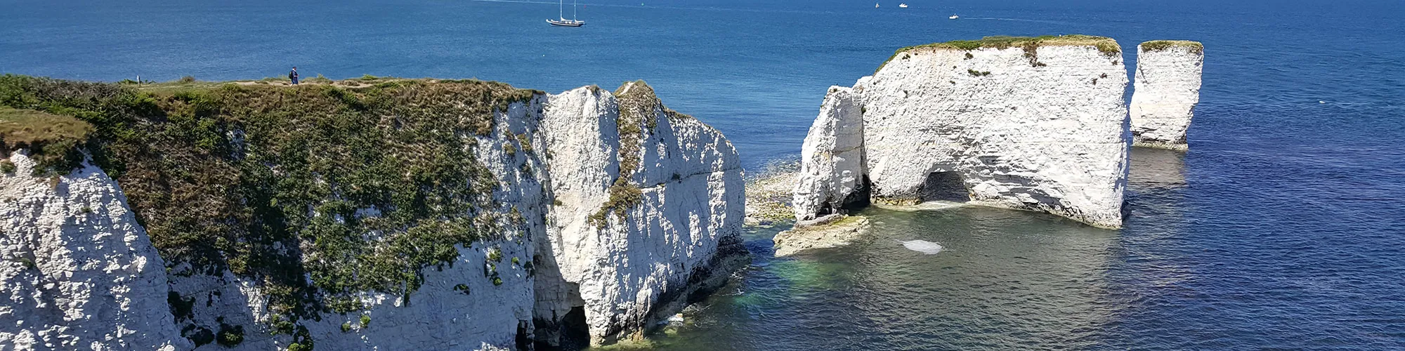
Continue though the narrow chalk path section and turn to your right following the rough track to a second gate, continue though the gate and follow the coast path along the top of the cliffs down the hill then left to the Foreland and Old Harry Rocks.
The Foreland and Old Harry Rocks
Elevation: 3 metres
OS Grid Reference: SZ 05435 82462
Lat, long: 50.64182, -1.92450
At the Foreland turn left and follow the wide track heading West to Studland.
Junction Manor Road and Watery Lane
Elevation: 19 metres
OS Grid Reference: SZ 03865 82422
Lat, long: 50.64148, -1.94670
At the junction with Manor Road and Watery Lane, turn right and continue up the hill past the pub and follow Manor Road to the junction with Beach Road.
Manor Road Beach Road Junction
Elevation: 24 metres
OS Grid Reference: SZ 03579 82747
Lat, long: 50.64440, -1.95074
At the junction with Beach Road, turn right and continue along Beach Road back to the car park and start of the walk.
Elevation Chart and Map
Move your mouse over the elevation line to view the location on the route map.
Walker & Cyclist Friendly Accommodation
Whether you’re exploring scenic trails, tackling longer routes, or simply enjoying a leisurely ride, choosing the right base makes all the difference. Below you’ll find details of some of the many local accommodation businesses that understands the needs of outdoor enthusiasts, helping you relax, recharge, and get ready for your next journey.