Hartland Way
3.6miles
Length
51metres
Elevation gain
21minutes
Average time
Walk
Ride Type
A flat 3.6 mile walk along good tracks following parts of the Hartland Way walk along disused clay mining railway lines.
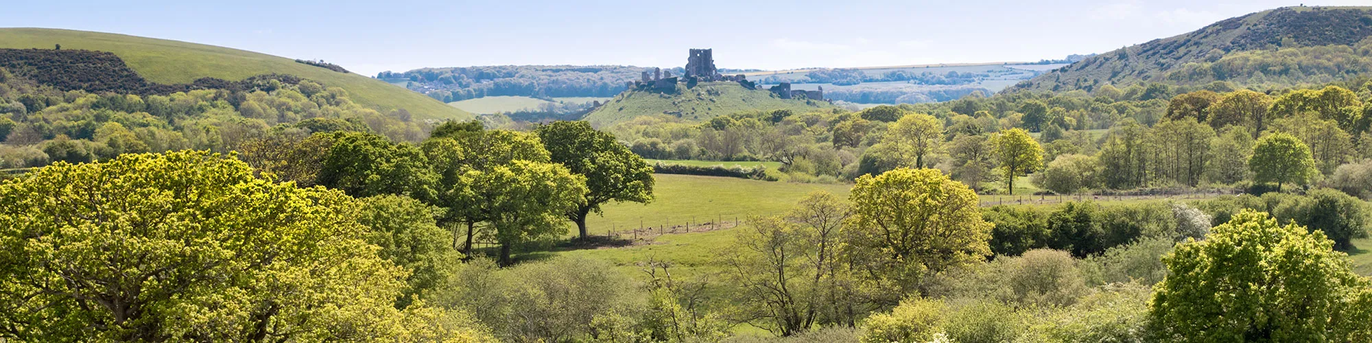
Some sections can be muddy in winter. The walk offers views across open heathland, across to Corfe Castle and a short woodland section.
Parking is available on the sides of the road near the junction with Middlebere Farm track.
Start: OSGB Grid Ref: SY 9634585325 between Corfe Castle and Arne, N50 40.055 W2 03.185
These routes have been recorded using a Garmin GPS unit. We cannot guarantee the accuracy of the available data files due to differences between GPS devices.
Route
Start of walk
Elevation: 10 metres
OS Grid Reference: SY 96344 85324
Lat, long: 50.66758, -2.05309
Go through the wooden gate and follow track south west though the bushes and onto open heathland going past a bird hide on your right and follow track as it curves left and then to your right until you come to a narrow cattlegrid with a sign on the right side.
Cattle Grid
Elevation: 19 metres
OS Grid Reference: SY 95412 84680
Lat, long: 50.66177, -2.06628
Go through the cattle grid and go across an open field until you come to a twin line of hedges with a sign post on the right side.
Twin Hedges
Elevation: 20 metres
OS Grid Reference: SY 95248 84580
Lat, long: 50.66087, -2.06860
Follow the track between the hedges following the old railway line route until you come to a gate next to a house.
Gate
Elevation: 24 metres
OS Grid Reference: SY 95238 84109
Lat, long: 50.65663, -2.06873
Go straight ahead at the gate and follow track until you come to a small uphill section with a wooden gate at the top.
Gate and Track
Elevation: 31 metres
OS Grid Reference: SY 95187 83668
Lat, long: 50.65267, -2.06945
Go through the gate and turn left following the level track in an east direction to a gate with a cattle grid.
Gate and Cattle Grid
Elevation: 27 metres
OS Grid Reference: SY 95447 83808
Lat, long: 50.65393, -2.06576
Go straight ahead at the cattle grid and follow the track until next cattle grid and junction with the tarmac road.
Cattle Grid and Junction
Elevation: 23 metres
OS Grid Reference: SY 95841 83971
Lat, long: 50.65540, -2.06020
Follow the road east until you come to a left turn with a farm in front of you. Continue left along the road a short distance until you come to a bridleway sign on your right marked "Sharford Bridge, Rempstone"
Sharford Bridge, Rempstone Sign
Elevation: 20 metres
OS Grid Reference: SY 96097 84117
Lat, long: 50.65672, -2.05658
Turn right and follow the bridleway until you come to the next gate.
Gate
Elevation: 20 metres
OS Grid Reference: SY 96173 84150
Lat, long: 50.65702, -2.05551
Go through the gate and follow the track up a slight hill until the next gate.
Gate
Elevation: 24 metres
OS Grid Reference: SY 96320 84213
Lat, long: 50.65758, -2.05343
Go through the gate and follow the path on the left side of the field, down the hill until you come to a gate on the left side.
Gate
Elevation: 17 metres
OS Grid Reference: SY 96572 84234
Lat, long: 50.65777, -2.04986
Go through the gate and follow the path across the field until the next gate.
Gate
Elevation: 11 metres
OS Grid Reference: SY 96550 84630
Lat, long: 50.66134, -2.05017
Go through the gate and follow path towards the gate and wooden bridge on the left side.
Gate and Wooden Bridge
Elevation: 11 metres
OS Grid Reference: SY 96587 84786
Lat, long: 50.66273, -2.04966
Turn left at the gate and follow the track through the trees to the wooden gate.
Wooden Gate
Elevation: 16 metres
OS Grid Reference: SY 96389 84929
Lat, long: 50.66402, -2.05246
Go through the gate out onto the open heathland and turn right following the fence and trees along the heathland and up small hill.
Double track
Elevation: 25 metres
OS Grid Reference: SY 96584 85534
Lat, long: 50.66946, -2.04970
Continue north east along the heathland until you come to trees and then go left down a double track in the heather.
Track
Elevation: 16 metres
OS Grid Reference: SY 96514 85519
Lat, long: 50.66933, -2.05069
Turn left at the bottom of the hill and follow the track back to the start of the walk.
Elevation Chart and Map
Move your mouse over the elevation line to view the location on the route map.
Walker & Cyclist Friendly Accommodation
Whether you’re exploring scenic trails, tackling longer routes, or simply enjoying a leisurely ride, choosing the right base makes all the difference. Below you’ll find details of some of the many local accommodation businesses that understands the needs of outdoor enthusiasts, helping you relax, recharge, and get ready for your next journey.