Durlston to Priest Way
4miles
Length
140metres
Elevation gain
27minutes
Average time
Walk
Ride Type
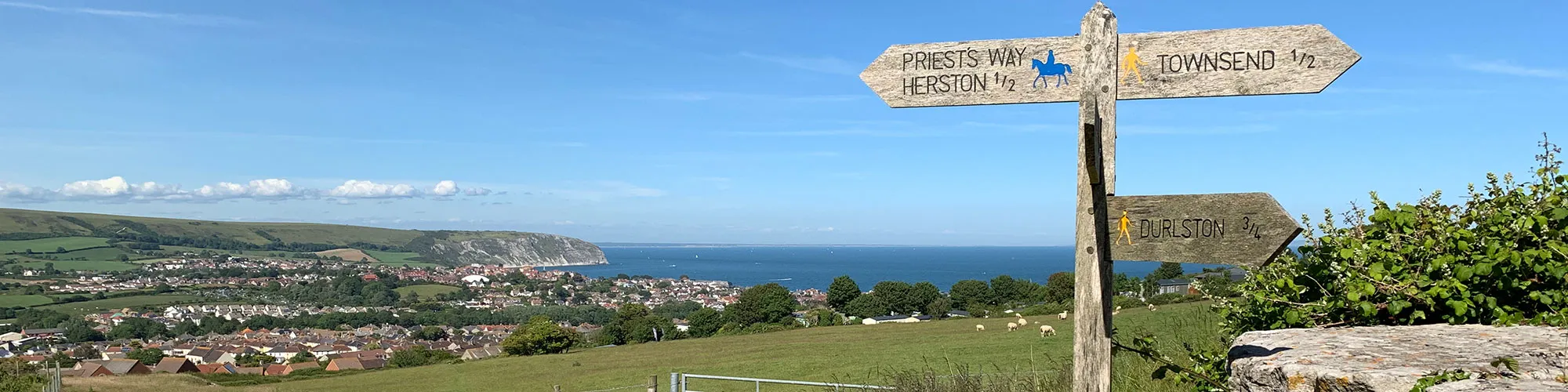
This is a 4 mile walk around Durlston Country Park and the Townsend Nature Reserve which crosses part of Priests Way.
The walk offers stunning views over the Isle of Purbeck, the Jurassic Coast and across to the Isle or Wight.
Start:
Durlston Country Park Car Park
OS Reference: SZ 03225 77353
These routes have been recorded using a Garmin GPS unit. We cannot guarantee the accuracy of the available data files due to differences between GPS devices.
Route
Start
Elevation: 80 metres
OS Grid Reference: SZ 03278 77335
Lat, long: 50.59574, -1.95505
Start from Car Park at Durlston Country park and follow tarmac path down back towards Swanage
Gate
Elevation: 70 metres
OS Grid Reference: SZ 03214 77672
Lat, long: 50.59876, -1.95595
Go left at the rough track and cross the road going through stile and continue west across field to wooden gate
Gate
Elevation: 72 metres
OS Grid Reference: SZ 03041 77638
Lat, long: 50.59846, -1.95839
At wooden gate go through gate and follow track to top-left corner of the field with second gate.
Gate
Elevation: 90 metres
OS Grid Reference: SZ 02884 77517
Lat, long: 50.59737, -1.96061
At gate bear left up and across field to wooden gate. Can be muddy in winter.
Gate
Elevation: 94 metres
OS Grid Reference: SZ 02711 77428
Lat, long: 50.59657, -1.96306
At wooden gate turn right and follow track down hill to stile/gate
Stile / Gate
Elevation: 86 metres
OS Grid Reference: SZ 02674 77616
Lat, long: 50.59826, -1.96357
Go through gate and follow path down field to metal gate
Metal Gate
Elevation: 66 metres
OS Grid Reference: SZ 02683 77791
Lat, long: 50.59984, -1.96345
Go through metal gate and follow track up hill and down until you come to a wooden gate on left side.
Gate
Elevation: 60 metres
OS Grid Reference: SZ 02621 78236
Lat, long: 50.60384, -1.96432
Turn left at the wooden gate into the Townsend nature reserve.
Wooden turn gate
Elevation: 88 metres
OS Grid Reference: SZ 02254 78147
Lat, long: 50.60304, -1.96951
When you reach the wooden gate at the far side of the Townsend nature reserve go through the gate onto the road a turn right down the hill.
Metal gate
Elevation: 88 metres
OS Grid Reference: SZ 02232 78176
Lat, long: 50.60330, -1.96982
A short distance down the hill you will come to a metal gate on your left. Go through the gate into the caravan park and go right along the road. Follow the road as it goes left until you come to the third T-junction. Turn right down the hill and the and then left at the next junction. Continue straight ahead until you come to a cross roads where you go straight across. The road goes up a shallow hill before turning right, there should be a stile on your left a short distance down the hill.If you get lost in the caravan park keep heading in a westerly direction and you should come out on a road on the far side of the park which goes from the top of the park to the bottom. The stile is near the top end of this road.
Wooden stile
Elevation: 88 metres
OS Grid Reference: SZ 02009 78273
Lat, long: 50.60417, -1.97298
Go through the stile and follow the wide path along the lower edge of the field above a caravan park.
Metal Turn Gate
Elevation: 81 metres
OS Grid Reference: SZ 01774 78266
Lat, long: 50.60411, -1.97629
Cross the road and go up the hill a short distance until you come to a footpath on the right. Follow the footpath through the metal gate and across the field until you come to an abandoned stone quarry.
Metal Gate and turn left
Elevation: 83 metres
OS Grid Reference: SZ 01548 78256
Lat, long: 50.60402, -1.97948
Go around the quarry building to the right and left through a metal gate and left up the steep stone track, following the sign post for Durlston.
Gate
Elevation: 115 metres
OS Grid Reference: SZ 01575 77303
Lat, long: 50.59545, -1.97911
At the top of the hill go straight ahead through the gate and south across the field to the next gate.
Gate
Elevation: 117 metres
OS Grid Reference: SZ 01576 77167
Lat, long: 50.59423, -1.97909
Go through the gate and follow the stone wall on your left down the hill.
Turn left
Elevation: 106 metres
OS Grid Reference: SZ 01569 77089
Lat, long: 50.59353, -1.97920
When you reach the end of the stone wall turn left and follow the track along the top of the field. This track will be muddy in the winter.
Broken wall
Elevation: 108 metres
OS Grid Reference: SZ 01786 77084
Lat, long: 50.59348, -1.97613
Go through the gap in the broken stone wall and follow the footpath west across the field towards Durlston Country Park.
Wooden kissing gate
Elevation: 102 metres
OS Grid Reference: SZ 02029 77040
Lat, long: 50.59309, -1.97269
At the wooden kissing gate go right along the footpath for a few metres until you reach the top ridge of the hill and then turn left following the footpath until you reach the next stone wall.
Stone stile
Elevation: 91 metres
OS Grid Reference: SZ 02299 77042
Lat, long: 50.59310, -1.96888
At the stone wall climb over the stone stile and bear left down across the field away from the sea and into the valley. The path will come to a t-junction at the base of the valley where you go east following the footpath until you reach a wooden gate,
Wooden gate
Elevation: 75 metres
OS Grid Reference: SZ 02555 77169
Lat, long: 50.59424, -1.96526
At the wooden gate go straight ahead and follow the path up towards Durlston with the lighthouse on your right.
Wooden kissing gate
Elevation: 82 metres
OS Grid Reference: SZ 02748 77203
Lat, long: 50.59454, -1.96254
At the wooden kissing gate continue east straight ahead until you reach the road and another wooden gate which may be open or closed depending on whether there are animals in the field.
Tarmac Road
Elevation: 84 metres
OS Grid Reference: SZ 03076 77213
Lat, long: 50.59463, -1.95790
Follow the road east under the trees until you reach the car park and the end of your walk.
Elevation Chart and Map
Move your mouse over the elevation line to view the location on the route map.
Walker & Cyclist Friendly Accommodation
Whether you’re exploring scenic trails, tackling longer routes, or simply enjoying a leisurely ride, choosing the right base makes all the difference. Below you’ll find details of some of the many local accommodation businesses that understands the needs of outdoor enthusiasts, helping you relax, recharge, and get ready for your next journey.