Corfe to Swanage Walk
6.2miles
Length
92metres
Elevation gain
36minutes
Average time
Walk
Ride Type
A 6.2 mile point to point walk from Corfe Castle, heading across Corfe Common and following footpaths along the valley to Swanage and ending at the railway station.
There is a hourly bus service from Swanage to Poole with stops at Corfe Castle, or you can take the train from Swanage to Corfe Castle.
Start:
The Square
Corfe Castle
OS Grid Ref: SY 96040 82086
These routes have been recorded using a Garmin GPS unit. We cannot guarantee the accuracy of the available data files due to differences between GPS devices.
Route
Start in Corfe Castle Square
Elevation: 24 metres
OS Grid Reference: SY 96039 82082
Lat, long: 50.63842, -2.05738
Start in the village square in Corfe Castle and follow West Street to Corfe Common
Corfe Common
Elevation: 36 metres
OS Grid Reference: SY 95843 81359
Lat, long: 50.63192, -2.06014
At the cattle grid at Corfe Common turn left and follow the path across the common heading east until you come to a large and small gate at the junction with Kingston Hill B3069.
Gate and Road
Elevation: 43 metres
OS Grid Reference: SY 96297 80945
Lat, long: 50.62819, -2.05372
At the Kingston Road, go straight across the road and through the next gate onto the eastern side of the common. Take care as this road can be very busy.
Gate and Valley Road A351
Elevation: 42 metres
OS Grid Reference: SY 96734 80771
Lat, long: 50.62663, -2.04754
At the gate on the eastern end of Corfe Common, go through the gate and follow the A351 heading east until you come to a bridge on the right side and junction. Take care as there is not a pavement on this road.
Junction
Elevation: 43 metres
OS Grid Reference: SY 96983 80672
Lat, long: 50.62574, -2.04401
Turn right at the junction and follow the road down the hill until it turns right, at the corner is a stile to go into the field alongside the railway line.
Stile
Elevation: 44 metres
OS Grid Reference: SY 97099 80509
Lat, long: 50.62427, -2.04237
Follow the edge of the field alongside the railway line
Campsite
Elevation: 39 metres
OS Grid Reference: SY 97415 80209
Lat, long: 50.62158, -2.03790
At the campsite road, continue straight ahead and follow the track heading east
Field
Elevation: 41 metres
OS Grid Reference: SY 97606 80092
Lat, long: 50.62053, -2.03520
Continue east across the road following the footpath until you come to a style and Haycrafts Lane road
Haycrafts Lane
Elevation: 77 metres
OS Grid Reference: SY 98347 79676
Lat, long: 50.61680, -2.02472
At Haycrafts Lane, turn right and follow the road heading up the hill until you come to a unmade track on your left with a bridleway sign.
Junction with Bridleway
Elevation: 82 metres
OS Grid Reference: SY 98478 79477
Lat, long: 50.61500, -2.02287
Turn left onto a rough track and then left at the gate following a narrow path down the hill into a field until you come to a metal gate.
Metal Gate
Elevation: 64 metres
OS Grid Reference: SY 98690 79555
Lat, long: 50.61570, -2.01988
Go through the metal gate and continue north-east towards farm buildings, this track can get overgrown in the summer. The path goes around the southern side of the farm buildings
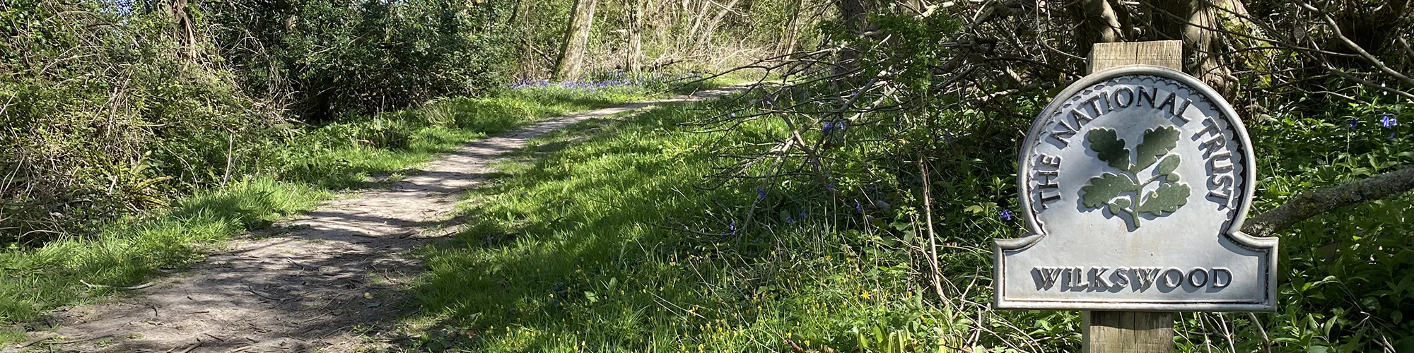
Wilkswood Gate
Elevation: 57 metres
OS Grid Reference: SY 98989 79677
Lat, long: 50.61680, -2.01565
At the gate entrance to Wilkswood, turn right and go through the gate. Follow the woodland trail unitl you come to a tarmac road.
Road
Elevation: 51 metres
OS Grid Reference: SY 99620 79617
Lat, long: 50.61626, -2.00674
At the tarmac road, turn left and follow the road to a cross roads with the A351
Valley Road cross roads
Elevation: 30 metres
OS Grid Reference: SY 99949 79620
Lat, long: 50.61629, -2.00208
At the cross roads, go straight across, take care as this is a busy road (sign for Knitson), follow the narrow road until you come to the farm and railway bridge.
Footpath
Elevation: 26 metres
OS Grid Reference: SZ 00195 79778
Lat, long: 50.61771, -1.99861
Walk past the farm buildings on your right and turn right at the footpath sign and turn left following the footpath up along the side of the field.
Path Splits
Elevation: 62 metres
OS Grid Reference: SZ 00491 80191
Lat, long: 50.62142, -1.99442
The footpath splits with one path going straight ahead and the other going to the right and east. Turn right and follow the path walking past a caravan site on your left to a narrow road
Burnhams Lane Junction
Elevation: 45 metres
OS Grid Reference: SZ 01046 80016
Lat, long: 50.61985, -1.98657
Continue straight ahead at the narrow road and continue heading east until you come to a T junction with Washpond Lane
Washpond Lane T Junction
Elevation: 25 metres
OS Grid Reference: SZ 01432 79985
Lat, long: 50.61957, -1.98112
Turn right at the T Junction and continue past the camp site until you come to a foothpath sign on your left and stile
Stile into Campsite
Elevation: 28 metres
OS Grid Reference: SZ 01490 79711
Lat, long: 50.61710, -1.98030
At the wooden stile, go into the campsite field and follow the left edge until you come to a gap in the hedge leading to another field. Continue across this field waling south-east until you come to a stile.
Stile
Elevation: 22 metres
OS Grid Reference: SZ 01706 79542
Lat, long: 50.61558, -1.97725
Go over the stile and follow the path walking past behind the industrial estate buildings until you turn right onto a road.
Prospect Way road
Elevation: 8 metres
OS Grid Reference: SZ 02034 79344
Lat, long: 50.61380, -1.97261
At the end of the footpath turn left onto Prospect Way and follow the road until you come to a T junction with Victoria Avenue.
T Junction
Elevation: 7 metres
OS Grid Reference: SZ 02128 79280
Lat, long: 50.61322, -1.97129
At the T Junction, turn left and follow Victoria Avenue until you come to a cross road junction with Northbrook Road.
Northbrook Road Cross Roads
Elevation: 4 metres
OS Grid Reference: SZ 02747 79106
Lat, long: 50.61166, -1.96253
At the junction with Northbrook Road, turn right and follow the road south up the hill until you come to a junction on the left with Gilbert Road.
Gilbert Road Junction
Elevation: 9 metres
OS Grid Reference: SZ 02704 78958
Lat, long: 50.61033, -1.96314
Turn left onto Gilbert Road and continue east until you come to the junction with Rempstone Road
Rempstone Road Junction
Elevation: 10 metres
OS Grid Reference: SZ 02954 78951
Lat, long: 50.61027, -1.95961
At Rempstone Road, turn right into Rempstone Road and follow the road to the roundabout and entrance to the railway station.
Entrance to Railway Station
Elevation: 5 metres
OS Grid Reference: SZ 02960 78908
Lat, long: 50.60988, -1.95952
Turn right and return to the Railway and Bus Station
Elevation Chart and Map
Move your mouse over the elevation line to view the location on the route map.
Walker & Cyclist Friendly Accommodation
Whether you’re exploring scenic trails, tackling longer routes, or simply enjoying a leisurely ride, choosing the right base makes all the difference. Below you’ll find details of some of the many local accommodation businesses that understands the needs of outdoor enthusiasts, helping you relax, recharge, and get ready for your next journey.