Studland Village to Agglestone Rock Walk
2.9miles
Length
113metres
Elevation gain
20minutes
Average time
Walk
Ride Type
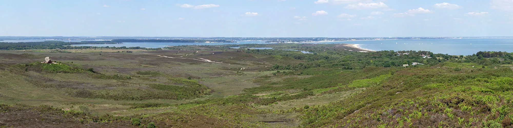
Starting in Middle Beach Car in Studland, this walking route takes you west across Studland Heath to Agglestone Rock on sandy and gravel footpaths and bridleway before returning to the village.
Start:
Middle Beach Car park
Beach Road
Studland
BH19 3AX
Grid Ref: SZ 03612 82838
These routes have been recorded using a Garmin GPS unit. We cannot guarantee the accuracy of the available data files due to differences between GPS devices.
Route
Start from Middle Beach Car Park in Studland
Elevation: 16 metres
OS Grid Reference: SZ 03599 82834
Lat, long: 50.64518, -1.95046
Exit the car park and turn right on Beach Road and follow the road to the junction with Ferry Road.
Ferry Road and Beach Road
Elevation: 34 metres
OS Grid Reference: SZ 03425 82553
Lat, long: 50.64266, -1.95293
Turn left onto Ferry road and continue up the road the village shop and cross roads.
Swanage Road and Ferry Road and Heath Green Road and School Lane
Elevation: 38 metres
OS Grid Reference: SZ 03443 82475
Lat, long: 50.64195, -1.95267
Cross the road onto Heath Green Road and continue for approx 500m until you come to Agglestone Road on the right side.
Heath Green Road and Agglestone Road
Elevation: 44 metres
OS Grid Reference: SZ 02953 82381
Lat, long: 50.64111, -1.95960
Turn right into Agglestone Road and follow the rough track as it turns left behind the houses and continue until the end of the road and two footpath entrances.
Gate
Elevation: 53 metres
OS Grid Reference: SZ 02759 82501
Lat, long: 50.64219, -1.96235
Continue straight ahead though the gate/entrance on the left side and continue straight ahead heading West along the path.
Junction with Bridleway
Elevation: 66 metres
OS Grid Reference: SZ 02646 82447
Lat, long: 50.64171, -1.96394
At the T junction with the bridleway, continue straight ahead and follow the path until you come to a cross junction with a gate on your left and a wide track on the right.
Cross Roads with Gate on left
Elevation: 89 metres
OS Grid Reference: SZ 02222 82201
Lat, long: 50.63950, -1.96993
At the cross roads turn right and follow the wide track down a small hill and up to a cross road junction.
Cross Junction
Elevation: 81 metres
OS Grid Reference: SZ 02088 82455
Lat, long: 50.64178, -1.97183
At the junction turn right and follow the rough track down to Agglestone Rock. Continue across the heathland past the rock until you come to a short steep hill and junction with a path to your left and right.
Track Junction
Elevation: 22 metres
OS Grid Reference: SZ 02640 83138
Lat, long: 50.64792, -1.96402
At the junction, turn right and follow the narrow track down into a wooded area to a stream and small wooden bridge on the right. Continue over the bridge and follow the track though a wooden gate and continue until you come to a cross roads with a bridleway on your right.
Wadmore Lane and Bridleway Junction
Elevation: 26 metres
OS Grid Reference: SZ 03066 82985
Lat, long: 50.64654, -1.95799
Turn right and follow the bridleway heading south until you come to a footpath on the left side.
Footpath Gate
Elevation: 33 metres
OS Grid Reference: SZ 03123 82623
Lat, long: 50.64329, -1.95719
At the gate and footpath, turn left and follow the footpath across a small open field, continue following the footpath signs into a wooded area and out onto a narrow road. Continue along the road to the B3351 Ferry Road.
Junction with B3351 Ferry Road
Elevation: 31 metres
OS Grid Reference: SZ 03372 82631
Lat, long: 50.64336, -1.95367
At the junction with the B3351 Ferry Road, turn right and continue up the road going past a bus stop until you come to the junction on the left with Beach Road.
Ferry Road and Beach Road Junction
Elevation: 33 metres
OS Grid Reference: SZ 03417 82578
Lat, long: 50.64288, -1.95304
Turn left onto Beach Road and follow the road back to the car park and start of the walk.
Elevation Chart and Map
Move your mouse over the elevation line to view the location on the route map.
Walker & Cyclist Friendly Accommodation
Whether you’re exploring scenic trails, tackling longer routes, or simply enjoying a leisurely ride, choosing the right base makes all the difference. Below you’ll find details of some of the many local accommodation businesses that understands the needs of outdoor enthusiasts, helping you relax, recharge, and get ready for your next journey.