Old Harry Ride
9miles
Length
280metres
Elevation gain
1hour 22minutes
Average time
Off Road
Ride Type
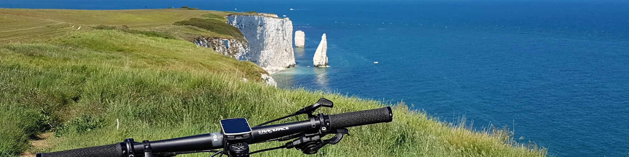
This 9-mile ride follows a spectacular route along the Purbeck Hills, offering some of the finest views in Dorset. Beginning in Swanage, the trail climbs steadily onto the ridge before heading east towards the famous chalk stacks of Old Harry Rocks. From this vantage point, you can look out across Studland Bay and the Isle of Wight, with the dramatic coastline stretching away in both directions.
After enjoying the panoramas from the hilltops, the trail continues through Studland Heath, a quieter and gentler section of the ride with sandy tracks, heathland, and open woodland.
From here, the route loops back towards Swanage, combining a mix of steady climbs, off-road tracks, and enjoyable downhill stretches. The constantly changing scenery, from high ridges to lowland heath, makes this a varied and rewarding ride, with plenty of opportunities to stop and admire the views.
Start:
Main Beach Car Park
Victoria Avenue
Swanage
BH19 1PW
OS Grid Ref: SZ 02667 79104
These routes have been recorded using a Garmin GPS unit. We cannot guarantee the accuracy of the available data files due to differences between GPS devices.
Route
Start
Elevation: 8 metres
OS Grid Reference: SZ 02712 79099
Lat, long: 50.61160, -1.96304
At the exit of the car park, turn right then left up Northbrook Road, continue to a mini roundabout.
Roundabout
Elevation: 25 metres
OS Grid Reference: SZ 02450 80303
Lat, long: 50.62243, -1.96672
Turn right at the roundabout and continue to the cross roads with Ulwell Road.
Junction and Cross Road
Elevation: 25 metres
OS Grid Reference: SZ 02649 80376
Lat, long: 50.62308, -1.96391
At the junction with Ulwell Road, continue straight ahead onto Whitecliff Road until you come to a stone building on your left and a bridleway sign on the left side.
Start of Whitecliff
Elevation: 45 metres
OS Grid Reference: SZ 02878 80759
Lat, long: 50.62653, -1.96067
Turn left and follow the steep bridleway up to a wooden gate, go though the gate and follow the very steep chalk path up the side of the hill. Continue though the next gate until you reach the top of the hill and a wooden sign post.
Top of Ballard Down
Elevation: 92 metres
OS Grid Reference: SZ 03347 81294
Lat, long: 50.63134, -1.95403
Turn right at the top of the hill and follow the well used path heading East. Continue though the next gate and follow the path along the top of the cliff turning North . Take care on this section as the path is often busy with walkers.
The Foreland
Elevation: 5 metres
OS Grid Reference: SZ 05407 82427
Lat, long: 50.64151, -1.92490
At the foreland and Old Harry Rocks, stop for a photo (not too close to the edge) and then continue left heading West following the wide path to Studland.
Manor Road junction
Elevation: 20 metres
OS Grid Reference: SZ 03902 82425
Lat, long: 50.64150, -1.94619
At the junction with Manor Road, continue straight ahead and follow Waterly Lane up the hill, turning right into School Lane until you come to a cross roads with the village shop on your right.
Cross Road
Elevation: 34 metres
OS Grid Reference: SZ 03437 82475
Lat, long: 50.64196, -1.95276
At the cross roads, continue straight ahead onto Heath Green Road and follow this until you come to a rough track on the right side marked Playing Field.
Junction
Elevation: 40 metres
OS Grid Reference: SZ 03210 82436
Lat, long: 50.64160, -1.95596
Turn right and follow the rough track until you come to a bridle way on the left side.
Bridleway
Elevation: 30 metres
OS Grid Reference: SZ 03020 82880
Lat, long: 50.64560, -1.95865
Turn left and follow the sandy bridleway heading west though heathland and past the golf course.
Golf Course
Elevation: 107 metres
OS Grid Reference: SZ 01781 82021
Lat, long: 50.63787, -1.97617
At the junction at the top of the hill and golf course, turn left and follow the bridleway to the B3351 and wooden gates.
Gate
Elevation: 109 metres
OS Grid Reference: SZ 01707 81873
Lat, long: 50.63655, -1.97722
Turn Right onto B3351 and continue along the road until you reach the next junction on your left.
Junction
Elevation: 114 metres
OS Grid Reference: SZ 01237 81794
Lat, long: 50.63584, -1.98387
Turn left at the junction and follow the road back down the hill to Ulwell Road.
Junction
Elevation: 78 metres
OS Grid Reference: SZ 01812 81219
Lat, long: 50.63066, -1.97574
Turn right onto Ulwell Road and continue along Ulwell Road to Swanage, Continue until you come to a junction on the right side with Seaward Road.
Junction onto Seaward Road
Elevation: 11 metres
OS Grid Reference: SZ 03044 79888
Lat, long: 50.61869, -1.95833
Turn Right onto Seaward Road.
Junction with De Moulham Road
Elevation: 14 metres
OS Grid Reference: SZ 02941 79881
Lat, long: 50.61863, -1.95979
Turn left onto De Moulham Road and continue along the road until the junction with Victoria Avenue.
Junction with Victoria Avenue
Elevation: 6 metres
OS Grid Reference: SZ 02987 79131
Lat, long: 50.61189, -1.95915
Turn right onto Victoria Avenue and follow the road back to the car park and start.
Elevation Chart and Map
Move your mouse over the elevation line to view the location on the route map.
Walker & Cyclist Friendly Accommodation
Whether you’re exploring scenic trails, tackling longer routes, or simply enjoying a leisurely ride, choosing the right base makes all the difference. Below you’ll find details of some of the many local accommodation businesses that understands the needs of outdoor enthusiasts, helping you relax, recharge, and get ready for your next journey.