Norden Singletrack
9miles
Length
140metres
Elevation gain
1hour 15minutes
Average time
Off Road
Ride Type
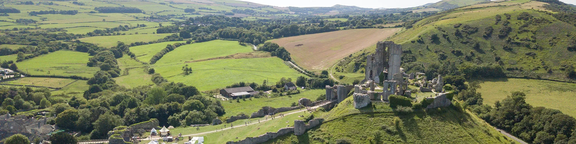
This varied cycling route begins at the historic village of Corfe Castle and quickly climbs onto the Purbeck Hills, where riders are rewarded with sweeping views across the surrounding countryside. From the ridge, the route drops down towards Creech, before tackling the twisting Norden single-track, a lively section that offers plenty of flow and excitement.
The return journey leads through the wide-open tracks and gravel trails of Rempstone Forest, mixing in stretches of flat forest roads with open fields and heathland. The constantly changing terrain keeps the ride engaging, combining challenging climbs, fast-flowing descents, and sections of technical single-track for those who enjoy testing their skills.
With its mix of landscapes and riding styles, this loop is perfect for cyclists seeking a route that combines stamina, speed, and technical ability while exploring some of Purbeck’s most varied scenery.
Start:
National Trust Car Park, below Corfe Castle
OS Grid Ref: SY 95904 82464
These routes have been recorded using a Garmin GPS unit. We cannot guarantee the accuracy of the available data files due to differences between GPS devices.
Route
Start at NT car park
Elevation: 24 metres
OS Grid Reference: SY 95914 82483
Lat, long: 50.64202, -2.05914
Exit the car park and turn left then right at T junction and follow road around the back of Corfe Castle
Junction
Elevation: 24 metres
OS Grid Reference: SY 95715 82193
Lat, long: 50.63941, -2.06196
After the stone bridge turn right at wooden gate and then left along track which goes up the side of the hill
Y junction
Elevation: 70 metres
OS Grid Reference: SY 94909 82170
Lat, long: 50.63920, -2.07335
Take the steep track to the right and past gate which is on the hill, continue along track on the top of the hill past gates until you come to a road
Road
Elevation: 88 metres
OS Grid Reference: SY 93082 82102
Lat, long: 50.63856, -2.09919
At the road go straight ahead and follow road down the hill and past quarry on left. Continue along road past camping site until you come to a sharp left corner. Bridleway is on the right of this corner.
Start of Singletrack
Elevation: 68 metres
OS Grid Reference: SY 93278 82846
Lat, long: 50.64526, -2.09643
Follow singletrack through woods and turn right at wooden bridge and continue along singletrack until you come to Norden camp site.
Norden Camping Site
Elevation: 44 metres
OS Grid Reference: SY 94752 82920
Lat, long: 50.64594, -2.07558
At camp site follow track through caravans and tents area and past farm yard to main road.
A351 Junction
Elevation: 33 metres
OS Grid Reference: SY 95244 82901
Lat, long: 50.64577, -2.06863
Turn left onto A351 and follow road over railway and take next right onto rough road.
Junction New Line
Elevation: 34 metres
OS Grid Reference: SY 94554 83454
Lat, long: 50.65075, -2.07839
Turn right onto rough track and follow past houses and turn right at bridleway sign. Continue along rough track to tarmac road.
Junction
Elevation: 12 metres
OS Grid Reference: SY 95834 83961
Lat, long: 50.65531, -2.06030
Continue straight ahead on road and follow until you come to a metal gate with stone pillars on each side. To the left of this gate is a sign post with wooden gates. Continue through wooden gates and follow track towards trees on right side.
Wooden gate
Elevation: 5 metres
OS Grid Reference: SY 96393 84920
Lat, long: 50.66394, -2.05239
At wooden gate, follow narrow track under trees until you come to a stone bridge with a wooden gate on far side.
Stone bridge and gate
Elevation: 6 metres
OS Grid Reference: SY 96665 84772
Lat, long: 50.66261, -2.04854
At gate continue across field following path and through next date into large field. Continue across path in field until you come to gate.
Road
Elevation: 22 metres
OS Grid Reference: SY 97106 84415
Lat, long: 50.65940, -2.04230
At road go straight ahead across the road and follow track through trees until you come to narrow gate at road.
Road
Elevation: 19 metres
OS Grid Reference: SY 97344 84099
Lat, long: 50.65656, -2.03893
Turn right onto narrow road and follow road South until you come to T junction.
B3351 and Thrashers Lane
Elevation: 42 metres
OS Grid Reference: SY 96832 82849
Lat, long: 50.64532, -2.04616
Turn right onto B3351 and follow road back to A351.
A351 and B3351
Elevation: 32 metres
OS Grid Reference: SY 95996 82408
Lat, long: 50.64135, -2.05798
Turn right and follow A351 back to start. Caution very busy road in summer months.
Elevation Chart and Map
Move your mouse over the elevation line to view the location on the route map.
Walker & Cyclist Friendly Accommodation
Whether you’re exploring scenic trails, tackling longer routes, or simply enjoying a leisurely ride, choosing the right base makes all the difference. Below you’ll find details of some of the many local accommodation businesses that understands the needs of outdoor enthusiasts, helping you relax, recharge, and get ready for your next journey.