Studland Village and Fort Henry Walk
2miles
Length
70metres
Elevation gain
13minutes
Average time
Walk
Ride Type
This is a 2 mile walk starting at the Middle Beach Car park in Studland exploring the paths and village of Studland in the Isle of Purbeck.
Start:
Middle Beach Car park
Beach Road
Studland
BH19 3AX
Grid Ref: SZ 03612 82838
These routes have been recorded using a Garmin GPS unit. We cannot guarantee the accuracy of the available data files due to differences between GPS devices.
Route
Start from Middle Beach Car Park in Studland
Elevation: 16 metres
OS Grid Reference: SZ 03599 82834
Lat, long: 50.64518, -1.95046
Exit the car park and turn left on Beach Road and then right on the footpath on the right side of the road marked Fort Henry.
Fort Henry Footpath
Elevation: 18 metres
OS Grid Reference: SZ 03622 82810
Lat, long: 50.64497, -1.95014
Follow the footpath past Fort Henry until you come to Manor Road. This path offers views over Studland Bay to Old Harry Rocks.
Manor Road
Elevation: 25 metres
OS Grid Reference: SZ 03771 82549
Lat, long: 50.64262, -1.94803
Turn right at Manor Road and then left onto a footpath on the left side of the road next to the car park entrance.
Footpath to St Nicholas Church
Elevation: 26 metres
OS Grid Reference: SZ 03757 82580
Lat, long: 50.64290, -1.94823
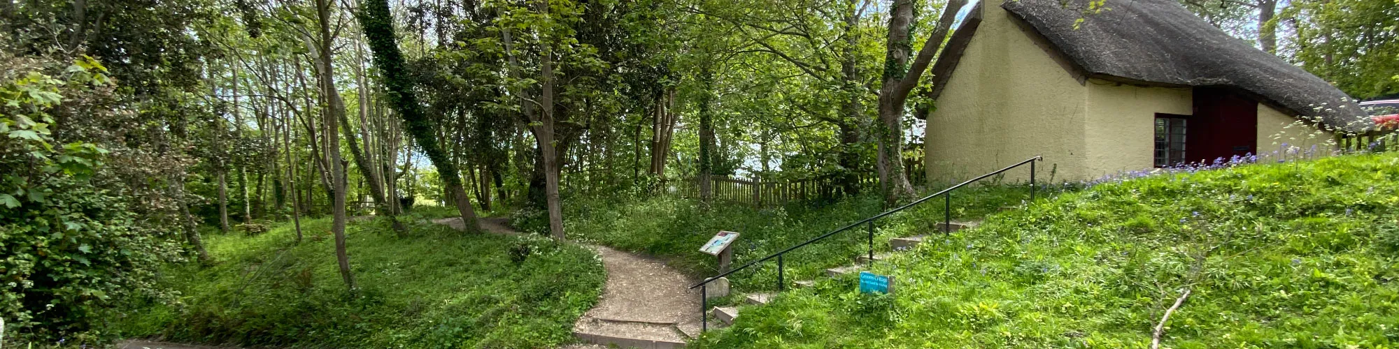
At the footpath to St Nicholas Church, go through the gates and follow the path to the church yard, past the graves until you come to the west end of the church building and a footpath heading North/South.
St Nicholas Church
Elevation: 33 metres
OS Grid Reference: SZ 03635 82514
Lat, long: 50.64230, -1.94996
At the west end of the church building, turn left onto the footpath and follow this until you come to Church Road, Follow the road until you come to the junction.
Church Road and School Lane junction
Elevation: 33 metres
OS Grid Reference: SZ 03635 82396
Lat, long: 50.64124, -1.94996
At the junction, turn right and follow School Lane up to the village shop and Ferry Road.
Ferry Road Junction
Elevation: 35 metres
OS Grid Reference: SZ 03443 82472
Lat, long: 50.64193, -1.95267
At the cross roads, go straight ahead and onto Heath Green Road. Before the Village Hall on your left is a small lane heading South, turn left and follow this path behind the houses until it comes down to Heath Green Road again.
Heath Green Road
Elevation: 39 metres
OS Grid Reference: SZ 03087 82403
Lat, long: 50.64131, -1.95770
At Heath Green Road, turn Left then continue along the road until you come to a rough track on the right with a sign for Playing Field.
Heath Green Road and Agglestone Road
Elevation: 45 metres
OS Grid Reference: SZ 02951 82379
Lat, long: 50.64109, -1.95962
Turn right onto the rough track and continue until you come to a footpath on the right side.
Woodland Footpath
Elevation: 40 metres
OS Grid Reference: SZ 02964 82519
Lat, long: 50.64235, -1.95945
Turn right onto the footpath and continue until it joins a wider path.
Wide Path
Elevation: 33 metres
OS Grid Reference: SZ 03140 82547
Lat, long: 50.64261, -1.95695
At the wider footpath / track, turn left and follow the path heading North until you come to a wide rough road.
Rough unmade road Wadmore Lane
Elevation: 25 metres
OS Grid Reference: SZ 03067 82985
Lat, long: 50.64654, -1.95799
At Wadmore Lane, turn right and follow the unmade road until you come to the Ferry Road / B3351.
Wadmore Lane - Ferry Road Junction
Elevation: 24 metres
OS Grid Reference: SZ 03289 82857
Lat, long: 50.64539, -1.95485
At the junction with the Ferry Road, go across the road, turn right then continue on the grass verge until the footpath on the left side.
Footpath
Elevation: 25 metres
OS Grid Reference: SZ 03331 82746
Lat, long: 50.64440, -1.95425
Turn Left onto the narrow footpath and follow it though the trees until you come out on Beach Road.
Beach Road
Elevation: 22 metres
OS Grid Reference: SZ 03504 82754
Lat, long: 50.64446, -1.95181
Turn Left at Beach Road and follow the road back to the car park and start of the walk.
Elevation Chart and Map
Move your mouse over the elevation line to view the location on the route map.
Walker & Cyclist Friendly Accommodation
Whether you’re exploring scenic trails, tackling longer routes, or simply enjoying a leisurely ride, choosing the right base makes all the difference. Below you’ll find details of some of the many local accommodation businesses that understands the needs of outdoor enthusiasts, helping you relax, recharge, and get ready for your next journey.