Durlston Country Park Short Walk
1.3miles
Length
114metres
Elevation gain
12minutes
Average time
Walk
Ride Type
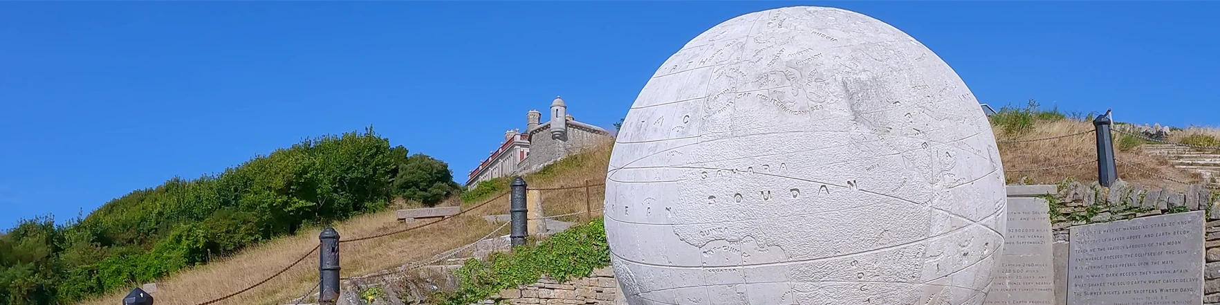
This is a short 1.3 mile walk exploring Durlston Country Park with the Great Stone Globe, Durlston Castle and Swanage Lighthouse on well made gravel tracks and tarmac sections.
This route has some steep sections near the lighthouse so take care and wear suitable footwear.
Route Video
Start: Car park at grid ref SZ 03269 77340 at Durlston Country Park
These routes have been recorded using a Garmin GPS unit. We cannot guarantee the accuracy of the available data files due to differences between GPS devices.
Route
Start Lighthouse Road and Car Park
Elevation: 66 metres
OS Grid Reference: SZ 03270 77335
Lat, long: 50.59573, -1.95516
Start in the car park at grid ref SZ 03269 77340 at Durlston Country Park
Left at St Catherines Road and Lighthouse Road
Elevation: 66 metres
OS Grid Reference: SZ 03284 77299
Lat, long: 50.59541, -1.95497
Turn left and follow the road heading east below the car park
Turn right to Durlston Castle
Elevation: 66 metres
OS Grid Reference: SZ 03316 77311
Lat, long: 50.59552, -1.95451
Turn right and follow the steep road down to Durlston Castle and follow the road on the right side down to the Stone Globe
Continue Down the Hill
Elevation: 40 metres
OS Grid Reference: SZ 03363 77263
Lat, long: 50.59509, -1.95385
Continue down the hill with Durlston Castle on the left.
Turn left towards the Globe
Elevation: 40 metres
OS Grid Reference: SZ 03427 77245
Lat, long: 50.59492, -1.95295
As you reach the end of the castle there is a fork in the path with a smaller path branching left. Turn left onto this path and follow it down the hill until you reach the stone globe.
Down the steps
Elevation: 40 metres
OS Grid Reference: SZ 03488 77235
Lat, long: 50.59483, -1.95208
When you reach the stone globe follow the steps down the hill until you reach the cliff path.
Turn right
Elevation: 15 metres
OS Grid Reference: SZ 03507 77212
Lat, long: 50.59462, -1.95182
Turn right and walk west along the cliff path.
Continue along the cliff path
Elevation: 40 metres
OS Grid Reference: SZ 03392 77180
Lat, long: 50.59434, -1.95344
When you reach the viewpoint continue along the cliff path heading west.
Through the gate
Elevation: 20 metres
OS Grid Reference: SZ 03130 76996
Lat, long: 50.59268, -1.95714
When you come to a gate go through it and follow the cliff path down along side the cliff edge down to Tilly Whim caves.Be careful here as the rocks and be slippery when they are wet.
Up the hill
Elevation: 34 metres
OS Grid Reference: SZ 03019 76969
Lat, long: 50.59244, -1.95871
When you reach the bottom of the hill at Tilly Whim caves continue up the opposite side towards the lighthouse. Continue along the cliff path with the lighthouse on your right.
Follow the road
Elevation: 6 metres
OS Grid Reference: SZ 02903 76872
Lat, long: 50.59157, -1.96035
When you reach the far side of the light house turn right onto the road. Follow the road up the hill for 600 metres (2000 feet) until you reach a gate.
Go through the gate
Elevation: 79 metres
OS Grid Reference: SZ 03079 77204
Lat, long: 50.59455, -1.95786
Go through the gate and continue along the road until you reach the car park and return to where you started.
Elevation Chart and Map
Move your mouse over the elevation line to view the location on the route map.
Walker & Cyclist Friendly Accommodation
Whether you’re exploring scenic trails, tackling longer routes, or simply enjoying a leisurely ride, choosing the right base makes all the difference. Below you’ll find details of some of the many local accommodation businesses that understands the needs of outdoor enthusiasts, helping you relax, recharge, and get ready for your next journey.