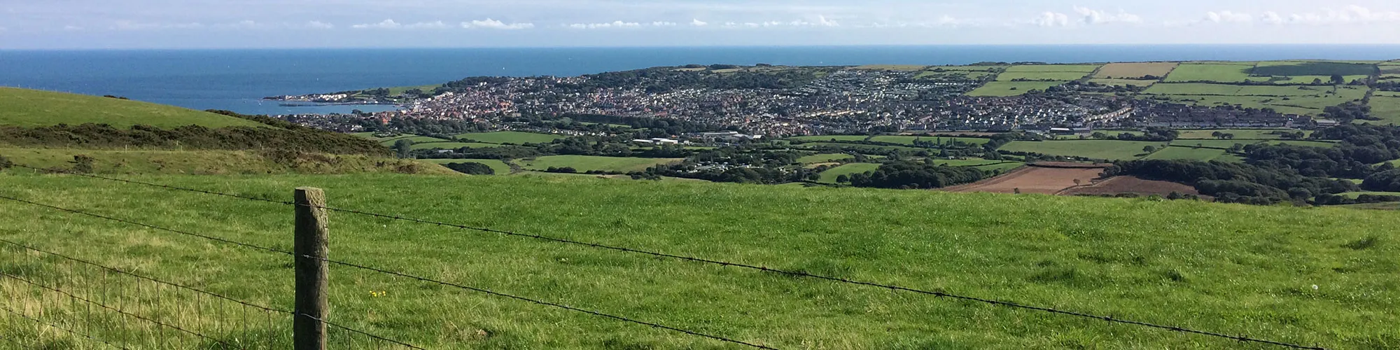
Purbeck Hills
13miles
Length
420metres
Elevation gain
1hour 59minutes
Average time
Off Road
Ride Type
A challenging ride around the Isle of Purbeck with stunning views aross Poole harbour and the historic nine barrow down. A long downhill takes you to the ruins of Corfe Castle before a long accent takes you to the top of the southern Purbeck hill. After a stretch of road riding the route continues along a gradual off-road decent on Priests Way back to Swanage.
Start:
These routes have been recorded using a Garmin GPS unit. We cannot guarantee the accuracy of the available data files due to differences between GPS devices.
Route
Car Park
Elevation: 11 metres
OS Grid Reference: SZ 02661 79086
Lat, long: 50.61148, -1.96376
Exit the car park and turn right onto Victoria Avenue.
Northbrook Road
Elevation: 12 metres
OS Grid Reference: SZ 02747 79108
Lat, long: 50.61168, -1.96254
Turn left onto Northbrook Road and continue up Northbrook Road. At mini roundabout go straight ahead and follow the road until the junction with the main road.
Junction
Elevation: 47 metres
OS Grid Reference: SZ 02226 80817
Lat, long: 50.62705, -1.96990
Turn left onto main road and continue along the road until a right bend with a wide track on your left and double gates.
Start of Off Road
Elevation: 65 metres
OS Grid Reference: SZ 01843 81128
Lat, long: 50.62985, -1.97531
Turn left and go through the gate and follow the rough track through the valley and up the side of the Purbeck Hills towards Corfe Castle.
Junction
Elevation: 95 metres
OS Grid Reference: SZ 01640 80933
Lat, long: 50.62809, -1.97817
Continue right up the hill at T junction on the track.
Metal Gate
Elevation: 171 metres
OS Grid Reference: SZ 01036 80897
Lat, long: 50.62777, -1.98672
Go straight ahead through the gate and continue to follow the track up the hill.
Top of the hill
Elevation: 204 metres
OS Grid Reference: SZ 00866 81106
Lat, long: 50.62966, -1.98912
At the top of the rough track bear left and follow the track along the top of the hill.
Gate
Elevation: 200 metres
OS Grid Reference: SZ 00540 81155
Lat, long: 50.63010, -1.99373
Continue straight ahead at the gate.
Gate
Elevation: 194 metres
OS Grid Reference: SZ 00025 81375
Lat, long: 50.63207, -2.00100
Continue straight ahead at the gate.
Gate
Elevation: 168 metres
OS Grid Reference: SY 98906 81694
Lat, long: 50.63494, -2.01683
Continue straight ahead at the gate.
Gate
Elevation: 137 metres
OS Grid Reference: SY 97727 82101
Lat, long: 50.63859, -2.03351
Continue straight ahead at the gate.
Cross Roads
Elevation: 112 metres
OS Grid Reference: SY 97258 82132
Lat, long: 50.63887, -2.04013
At the transmitter site, continue straight ahead at the gate and follow the track down the hill towards Corfe Castle. At the next gate continue straight ahead on the tarmac road (Sandy Hill Lane) down to the T junction with the A351 and East Street.
T Junction A351
Elevation: 22 metres
OS Grid Reference: SY 96102 82185
Lat, long: 50.63934, -2.05649
Turn left onto East Street and follow the road up the hill until you come to the village square and turn right into the square . This road is very busy so take care when turning right at the village square.
The Square
Elevation: 31 metres
OS Grid Reference: SY 96058 82091
Lat, long: 50.63850, -2.05711
Turn right into the village square and continue along West Street until you come to a cattle grid at the entrance to Corfe Common.
Corfe Common
Elevation: 44 metres
OS Grid Reference: SY 95841 81356
Lat, long: 50.63188, -2.06016
Turn left onto the common before the cattle grid and follow fenced in section for approx 30m until you come to a gate.
Gate
Elevation: 43 metres
OS Grid Reference: SY 95866 81320
Lat, long: 50.63157, -2.05982
Go straight ahead at the gate and follow the path across the common until you come to a cross roads and gate at the B3069.
B3069 Crossing
Elevation: 51 metres
OS Grid Reference: SY 96304 80940
Lat, long: 50.62815, -2.05362
Go straight across the B3069 onto the east section of Corfe Common and go through a wooden gate and follow the track up a small slope and then bear left and follow the track east across the common until you come to a wooden gate and Valley Road.
Valley Road junction
Elevation: 56 metres
OS Grid Reference: SY 96729 80766
Lat, long: 50.62659, -2.04761
Turn right onto Valley Road and follow the road until you come to a junction on your right with a sign for Afflington Manor Farm.
Junction Afflington Manor Farm
Elevation: 56 metres
OS Grid Reference: SY 96988 80668
Lat, long: 50.62571, -2.04394
Turn right onto the narrow road and follow the road until you come to the farm yard.
Farm Bridleway
Elevation: 50 metres
OS Grid Reference: SY 97038 80034
Lat, long: 50.62000, -2.04323
Go through the farm yard and turn right behind the farm buildings and follow the bridleway up a rough track
Gate
Elevation: 72 metres
OS Grid Reference: SY 96789 79850
Lat, long: 50.61835, -2.04675
Continue to follow the rough track up the side of the valley.
Gate
Elevation: 136 metres
OS Grid Reference: SY 96973 79353
Lat, long: 50.61388, -2.04414
Continue to follow the rough track up the side of the valley until you come to a T junction and road.
Road Junction
Elevation: 147 metres
OS Grid Reference: SY 96939 79186
Lat, long: 50.61238, -2.04462
Turn left onto the B3069 and follow the road towards Swanage until you come to the third junction on the right side with a red phone box on the left and sign for Acton.
Junction Acton
Elevation: 134 metres
OS Grid Reference: SY 98893 78663
Lat, long: 50.60768, -2.01700
Turn right and follow the narrow road past the houses in Acton which then changes to a rough track which bears left and then right to the Priests Way
Priests Way Junction
Elevation: 141 metres
OS Grid Reference: SY 98988 78008
Lat, long: 50.60179, -2.01566
At the T junction, turn left and follow the Priests Way track down the hill past several gates until you come to a left turn with an open field on your left. Follow the track down to a wooden gate.
Wooden Gate
Elevation: 95 metres
OS Grid Reference: SZ 00742 78124
Lat, long: 50.60284, -1.99087
Go through the gate and turn right and follow the track past farm buildings to a metal gate.
Metal Gate
Elevation: 96 metres
OS Grid Reference: SZ 00962 78172
Lat, long: 50.60327, -1.98776
Go straight ahead at the metal gate and through the next metal gate and follow the rough track heading east.
Gate
Elevation: 95 metres
OS Grid Reference: SZ 01378 78229
Lat, long: 50.60378, -1.98188
Continue straight ahead at the gate until you come to a junction with a wooden sign straight ahead.
Junction
Elevation: 94 metres
OS Grid Reference: SZ 01551 78248
Lat, long: 50.60395, -1.97945
Turn left and follow the narrow track down the hill and though next gate. At a small cross roads turn right and follow the narrow track down the hill until you come to a T junction on a tarmac road.
Junction
Elevation: 51 metres
OS Grid Reference: SZ 01907 78583
Lat, long: 50.60696, -1.97441
Turn left onto the road and at the next Y junction continue straight ahead and then bear right along Priests Road until you come to a steep road on your left, Gordon Road. Go down the hill until you come to the cross roads with the High Street.
High Street
Elevation: 19 metres
OS Grid Reference: SZ 02378 78761
Lat, long: 50.60856, -1.96776
Turn right onto the High Street then bear left down Court hill until you come to a cross roads at the bottom of the hill.
Cross Roads Junction
Elevation: 11 metres
OS Grid Reference: SZ 02511 78859
Lat, long: 50.60945, -1.96587
Go straight ahead at the junction onto Court Road and follow the road past the railway on your left until you come to a T junction with a stone bridge on the left side. Turn left over the bridge and follow Northbrook Road down to Victoria Avenue cross roads and turn left back to the start.
Elevation Chart and Map
Move your mouse over the elevation line to view the location on the route map.
Walker & Cyclist Friendly Accommodation
Whether you’re exploring scenic trails, tackling longer routes, or simply enjoying a leisurely ride, choosing the right base makes all the difference. Below you’ll find details of some of the many local accommodation businesses that understands the needs of outdoor enthusiasts, helping you relax, recharge, and get ready for your next journey.