Old Harry and Nine Barrow Down
15miles
Length
455metres
Elevation gain
2hours 15minutes
Average time
Off Road
Ride Type
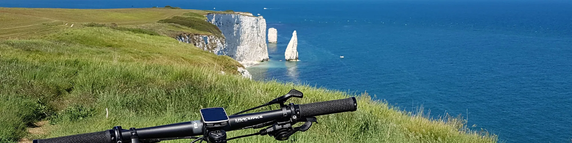
Starting in Swanage, this route offers a challenging and scenic ride through some of the best landscapes in Purbeck. The ride begins with a steep ascent over Ballard Down, leading you along the Purbeck Hills towards the dramatic chalk cliffs of Old Harry Rocks. From here, you can enjoy breathtaking views across Studland Bay and the English Channel.
The route then continues west, dropping down onto the wide, flat gravel tracks around Rempstone Forest. This section provides a welcome break from the climbs, with easier riding through quiet woodland and open heathland. After crossing this flatter stretch, the trail rises sharply once again, taking you back onto the spine of the Purbeck Hills.
The final part of the ride follows the ridge eastwards, offering sweeping views over Poole Harbour on one side and the rolling countryside of Purbeck on the other. A long descent brings you down to Ulwell, before the route loops back to Swanage.
This ride combines tough off-road climbs with exhilarating downhill sections, making it a rewarding challenge for experienced cyclists. The constantly changing scenery, from coastal cliffs to heathland and high ridges, ensures there is always something new to enjoy along the way.
Start:
Main Beach Car Park
Victoria Avenue
Swanage
BH19 1PW
OS Grid Ref: SZ 02667 79104
These routes have been recorded using a Garmin GPS unit. We cannot guarantee the accuracy of the available data files due to differences between GPS devices.
Route
Car Park
Elevation: 116 metres
OS Grid Reference: SZ 02673 79114
Lat, long: 50.61173, -1.96358
Start from the Car park in Victoria Avenue, exit the car park and turn right onto Victoria Avenue and then left onto Northbrook Road and continue up Northbrook Road. At mini roundabout go straight ahead and follow the road until the junction with the main road.
T Junction
Elevation: 42 metres
OS Grid Reference: SZ 02222 80815
Lat, long: 50.62704, -1.96995
Turn left onto main road and continue along the road and straight ahead at next Y junction and follow the road up a hill until you come to a bridleway sign and track on your right which goes up across an open field.
Bridleway
Elevation: 102 metres
OS Grid Reference: SZ 02021 81625
Lat, long: 50.63432, -1.97279
Turn right and go through the gate and follow the double track up the hill to the Obelisk monument.
Obelisk
Elevation: 134 metres
OS Grid Reference: SZ 02232 81298
Lat, long: 50.63138, -1.96980
At the stone Obelisk continue straight ahead up the hill and follow the path along the top of the ridgeway past 3 gates until the track turns left along the side of the cliff and descends to Old Harry Rocks and The Foreland.
The Foreland
Elevation: 3 metres
OS Grid Reference: SZ 05450 82466
Lat, long: 50.64185, -1.92428
Turn left at The Foreland and follow wide track back to Studland village.
Junction
Elevation: 19 metres
OS Grid Reference: SZ 03865 82421
Lat, long: 50.64147, -1.94671
At village go straight ahead at junction and follow road up hill and to the right to the village shop and cross roads.
Cross Roads
Elevation: 35 metres
OS Grid Reference: SZ 03439 82472
Lat, long: 50.64193, -1.95273
Turn Right at the cross roads / village shop and follow the road down through the village and past the National Trust car park on your right. The road will go down into a dip then up a small slope to your right followed by a sweeping left turn. Continue until you come to a rough track on the left side a bus stop.
Junction and Rough Track
Elevation: 7 metres
OS Grid Reference: SZ 02508 84344
Lat, long: 50.65877, -1.96588
Turn left and follow the rough track down across the heathland past a farm house and continue right when you come to a wooden gate.
Gate and Junction
Elevation: 4 metres
OS Grid Reference: SZ 01832 84495
Lat, long: 50.66013, -1.97544
Continue right and follow the track down a small hill and over a bridge. At a metal gate go straight ahead and follow the bridleway signs along the track until you come to a tarmac road.
Tarmac road
Elevation: 17 metres
OS Grid Reference: SZ 01029 84867
Lat, long: 50.66347, -1.98680
Turn left onto the road and continue along the road until you come to a junction with a rough track straight ahead and tarmac roads to your left and right.
Junction
Elevation: 22 metres
OS Grid Reference: SY 99424 84053
Lat, long: 50.65615, -2.00951
Turn left at the junction and follow the road past a farm house on your left and continue along the road and up towards the Purbeck Hills.
Cross Roads
Elevation: 58 metres
OS Grid Reference: SY 98903 82875
Lat, long: 50.64556, -2.01687
Continue straight ahead at the cross roads until you come to the next junction
Junction
Elevation: 79 metres
OS Grid Reference: SY 98723 82340
Lat, long: 50.64075, -2.01942
Go across the road and follow a rough track though trees and continue until the track bears right with a junction on your left side.
Track Junction
Elevation: 102 metres
OS Grid Reference: SY 98631 82076
Lat, long: 50.63837, -2.02072
Turn left and go up a short steep section of track to a gate. Go through the gate and follow the track up the side of the hill until you come to a small wooden gate.
Gate
Elevation: 157 metres
OS Grid Reference: SY 98998 81687
Lat, long: 50.63488, -2.01554
Go through the wooden gate and turn left and follow a wide track up a hill and bear right when the track splits to the left. Continue along the track along the top of the Purbeck Hills heading East towards the transmitter towers.
Downhill Time!
Elevation: 194 metres
OS Grid Reference: SZ 00826 81116
Lat, long: 50.62974, -1.98968
Follow the rough track down the side of the Purbeck Hills until you come to a metal gate. Continue straight ahead at the gate and follow the track down and to your left when you go under electric power lines until you come to a metal gate and the road.
Ulwell Road
Elevation: 68 metres
OS Grid Reference: SZ 01848 81135
Lat, long: 50.62991, -1.97523
Turn right onto Ulwell Road and follow the road towards Swanage until you come to a cross roads with Washpond Lane on your right.
Ulwell Road and Washpond Lane
Elevation: 27 metres
OS Grid Reference: SZ 02664 80384
Lat, long: 50.62315, -1.96370
Turn right onto Washpond Lane and at the next roundabout turn left onto Northbrook Road
Washpond Lane and Northbrook Road
Elevation: 30 metres
OS Grid Reference: SZ 02450 80303
Lat, long: 50.62243, -1.96672
Turn left onto Northbrook road and continue along the road back to the start of the route.
Elevation Chart and Map
Move your mouse over the elevation line to view the location on the route map.
Walker & Cyclist Friendly Accommodation
Whether you’re exploring scenic trails, tackling longer routes, or simply enjoying a leisurely ride, choosing the right base makes all the difference. Below you’ll find details of some of the many local accommodation businesses that understands the needs of outdoor enthusiasts, helping you relax, recharge, and get ready for your next journey.