Nine Barrow Down and Rempstone Forest
10.6miles
Length
350metres
Elevation gain
1hour 37minutes
Average time
Off Road
Ride Type
This scenic hilly ride begins in Swanage and climbs steadily onto the ridge of the Purbeck Hills, rewarding you with far-reaching views across the coast and countryside. From the high points, the route then descends towards Rempstone Forest, where the landscape changes to quieter gravel tracks.
The return leg takes you back via the wide, open spaces of Studland Heath, offering a contrast of heathland scenery and a more relaxed pace after the earlier climbs. With its mixture of steep ascents, fast descents, and easier gravel stretches, this ride provides a varied experience that combines challenge with enjoyment.
It’s a route well suited to cyclists who enjoy hill climbing and off-road riding, with the added reward of some of the finest views in Purbeck along the way.
Start:
Start from layby on Ulwell Road at the Welcome to Swanage signs
OS Grid Ref: SZ 02171 80919
These routes have been recorded using a Garmin GPS unit. We cannot guarantee the accuracy of the available data files due to differences between GPS devices.
Route
Start
Elevation: 55 metres
OS Grid Reference: SZ 02177 80911
Lat, long: 50.62790, -1.97058
Start at the layby on the side of the Ulwell Road on the outskirts of Swanage. Head north along the road out of Swanage.
Y Junction
Elevation: 74 metres
OS Grid Reference: SZ 01813 81227
Lat, long: 50.63074, -1.97573
Turn left at the junction and follow the road along the side of the Purbeck hills and up a steep hill to the next T junction
T Junction
Elevation: 109 metres
OS Grid Reference: SZ 01237 81794
Lat, long: 50.63584, -1.98388
Turn left at the junction and continue until the road turns right to the viewpoint. On your left is a gate and bridleway.
Gate and start of Off road
Elevation: 108 metres
OS Grid Reference: SZ 00831 81812
Lat, long: 50.63601, -1.98961
Go through the gate and follow the bridleway up towards Nine Barrow Down until you come to the next gate
Gate
Elevation: 140 metres
OS Grid Reference: SZ 00766 81457
Lat, long: 50.63281, -1.99052
Go straight ahead at the gate and follow the rough track through the woods and up to the top of the hill. There is a second gate approx half way up the hill and continue following the track until you come to an open field. Follow the track across the field until you come to a gate at the top.
Gate
Elevation: 173 metres
OS Grid Reference: SZ 00271 81331
Lat, long: 50.63168, -1.99753
Continue through the gate and follow the track which goes to your right until you come to the main bridleway track at the top of the hill. Turn right and follow the track until you come to the next gate
Gate
Elevation: 178 metres
OS Grid Reference: SZ 00025 81373
Lat, long: 50.63206, -2.00100
Go through the gate and follow the track along the top of the hill past the barrows on your right until you come to the next set of gates after a short downhill section. There is a gate on the right side of the track just before the double gates. Turn right at the gate.
Gate and start of downhill
Elevation: 157 metres
OS Grid Reference: SY 98993 81687
Lat, long: 50.63488, -2.01560
Turn right through the gate and follow the wide track to the left down the hill until you come to another gate, continue through the gate and down around a sharp right bend to a T junction and wider track
T Junction rough track
Elevation: 101 metres
OS Grid Reference: SY 98641 82082
Lat, long: 50.63843, -2.02058
Turn right onto the rough track and continue down the track until you come to a gate with a gap on the side and a small parking area at the road.
B3351 Crossing
Elevation: 79 metres
OS Grid Reference: SY 98718 82335
Lat, long: 50.64070, -2.01949
At the road continue straight ahead and follow the narrow road down the hill until you come to a cross roads and junction.
Junction
Elevation: 58 metres
OS Grid Reference: SY 98902 82877
Lat, long: 50.64558, -2.01689
Turn right and follow the narrow road heading east, the road turns slightly left past a house and onto a rough track. Follow this until you come to a gate at the edge of the trees.
Gate and start of forest track
Elevation: 40 metres
OS Grid Reference: SY 99880 83037
Lat, long: 50.64702, -2.00306
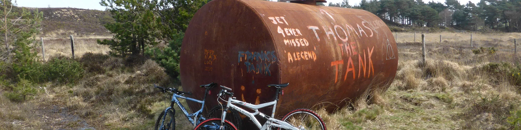
Continue straight ahead through the gate and follow the wide track up the hill heading east until you come to a left turn with a large metal tank with "Franks Tank" painted on the side.
Franks Tank
Elevation: 52 metres
OS Grid Reference: SZ 00433 82848
Lat, long: 50.64532, -1.99523
At the large metal tank, turn left and follow the track up a small hill and continue along the track on the edge of the heathland until you come to a junction with a bridleway on the right side.
Junction and stream crossing
Elevation: 14 metres
OS Grid Reference: SZ 01501 84185
Lat, long: 50.65734, -1.98012
Turn right and continue across the stream (or use bridge) and up a short hill to a gate
Gate
Elevation: 11 metres
OS Grid Reference: SZ 01587 84188
Lat, long: 50.65736, -1.97891
Turn left at the gate and follow the bridleway track past a barn (on right side) and continue straight ahead to the next gate.
Gate and junction
Elevation: 4 metres
OS Grid Reference: SZ 01834 84496
Lat, long: 50.66014, -1.97542
Go through the gate and follow the wide track heading south east until you come to the road with a gate on your right side.
Road junction and gate
Elevation: 8 metres
OS Grid Reference: SZ 02526 84337
Lat, long: 50.65871, -1.96562
At the road, turn right though the gate and follow the wide track across the heathland until you come to a junction with the track on your left.
Junction
Elevation: 32 metres
OS Grid Reference: SZ 02477 83328
Lat, long: 50.64963, -1.96633
Turn left and follow the sandy track down to the river crossing. This can be muddy in winter and loose sand in the summer months.
River crossing and gate
Elevation: 21 metres
OS Grid Reference: SZ 02815 83154
Lat, long: 50.64806, -1.96154
At the river/stream, turn right and go straight ahead at the next gate and follow the bridleway up the hill until you come to a cross road junction with bridleway signs.
Cross roads junction
Elevation: 25 metres
OS Grid Reference: SZ 03065 82981
Lat, long: 50.64651, -1.95802
Turn right at the cross roads and follow the track until you come to a T junction on your right side.
Junction and gate
Elevation: 29 metres
OS Grid Reference: SZ 03019 82885
Lat, long: 50.64564, -1.95866
Turn right at the junction and continue straight ahead through the gate, follow the rough singletrack up the side of the heathland continuing though gates until you come to a T junction at the top of the golf course.
T Junction Golf Course
Elevation: 108 metres
OS Grid Reference: SZ 01775 82016
Lat, long: 50.63783, -1.97626
Turn left at the golf course and follow the narrow track up the hill until you come to the road with a small parking area on the right side.
Road junction
Elevation: 114 metres
OS Grid Reference: SZ 01711 81880
Lat, long: 50.63661, -1.97717
Turn left onto the road and continue along a short flat section and down a steeper section until you come to the next junction on your right. Caution busy road so take care.
T junction
Elevation: 78 metres
OS Grid Reference: SZ 02436 81966
Lat, long: 50.63738, -1.96691
Turn right then right again and follow the road down the hill towards Swanage and back to the start.
Elevation Chart and Map
Move your mouse over the elevation line to view the location on the route map.
Walker & Cyclist Friendly Accommodation
Whether you’re exploring scenic trails, tackling longer routes, or simply enjoying a leisurely ride, choosing the right base makes all the difference. Below you’ll find details of some of the many local accommodation businesses that understands the needs of outdoor enthusiasts, helping you relax, recharge, and get ready for your next journey.