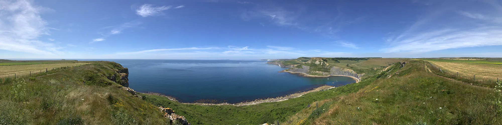
Chapmans Pool
14miles
Length
490metres
Elevation gain
2hours 9minutes
Average time
Off Road
Ride Type
This 14-mile cycling route runs along the ridge of the Purbeck Hills, offering superb views across the coast and countryside before dropping down towards the historic village of Corfe Castle. From here the ride crosses the valley on a mix of open fields and bridleways, giving a real sense of space and variety.
The highlight for many is the descent towards Chapman’s Pool, where the route follows a twisting, technical single-track that demands concentration and confident bike handling. After reaching the narrow stone road which leads to the coast, the return leg takes you back to Swanage via the picturesque village of Worth Matravers and then along the historic Priests Way, a traditional stone path once used by clergymen travelling between the settlements.
With its combination of challenging climbs, technical sections, and stunning scenery, this ride is ideal for experienced cyclists looking for both adventure and variety in the Purbeck landscape.
Start:
Main Beach Car Park
Victoria Avenue
Swanage
BH19 1PW
OS Grid Ref: SZ 02667 79104
These routes have been recorded using a Garmin GPS unit. We cannot guarantee the accuracy of the available data files due to differences between GPS devices.
Route
Victoria Avenue Car Park
Elevation: 13 metres
OS Grid Reference: SZ 02675 79113
Lat, long: 50.61173, -1.96355
Start from the Car park in Victoria Avenue, exit the car park and turn right onto Victoria Avenue. Turn left onto Northbrook Road and continue up Northbrook Road. At mini roundabout go straight ahead and follow the road until the junction with the main road.
Ulwell Road and Darkie Lane
OS Grid Reference: SZ 02231 80820
Lat, long: 50.62708, -1.96981
Turn left onto main road and continue along the road until a right bend with a wide track on your left and double gates.
Start of Off Road
Elevation: 64 metres
OS Grid Reference: SZ 01848 81127
Lat, long: 50.62984, -1.97523
Turn left and go through the gate and follow the rough track through the valley and up the side of the Purbeck Hills towards Corfe Castle. Follow the track along the top of the hill, going through several gates until you come to the second transmitter site and continue straight ahead at the gate and follow the track down the hill towards Corfe Castle. At the next gate continue straight ahead on the tarmac road (Sandy Hill Lane) down to the T junction with the A351 and East Street.
T Junction A351
OS Grid Reference: SY 96103 82191
Lat, long: 50.63940, -2.05647
Turn left onto East Street and follow the road up the hill until you come to the village square and turn right into the square . This road is very busy so take care when turning right at the village square.
The Square
OS Grid Reference: SY 96057 82096
Lat, long: 50.63854, -2.05713
Turn right into the village square and continue along West Street until you come to a cattle grid at the entrance to Corfe Common.
Corfe Common
Elevation: 39 metres
OS Grid Reference: SY 95844 81364
Lat, long: 50.63195, -2.06012
Turn left onto the common before the cattle grid and follow fenced in section for approx 30m until you come to a gate.
Gate
Elevation: 41 metres
OS Grid Reference: SY 95867 81321
Lat, long: 50.63157, -2.05980
Go straight ahead at the gate and follow the path across the common until you come to a cross roads and gate at the B3069.
B3069 Crossing
Elevation: 51 metres
OS Grid Reference: SY 96304 80944
Lat, long: 50.62818, -2.05362
Go straight across the B3069 onto the east section of Corfe Common and go through a wooden gate and follow the track up a small slope and then bear left and follow the track east across the common until you come to a wooden gate and Valley Road.
Valley Road junction
Elevation: 54 metres
OS Grid Reference: SY 96728 80767
Lat, long: 50.62660, -2.04763
Turn right onto Valley Road and follow the road until you come to a junction on your right with a sign for Afflington Manor Farm.
Junction Afflington Manor Farm
Elevation: 55 metres
OS Grid Reference: SY 96990 80668
Lat, long: 50.62571, -2.04392
Turn right onto the narrow road and follow the road until you come to the farm yard.
Farm Bridleway
Elevation: 50 metres
OS Grid Reference: SY 97024 80032
Lat, long: 50.61998, -2.04343
Go through the farm yard and turn right behind the farm buildings and follow the bridleway up a rough track.
Gate
Elevation: 113 metres
OS Grid Reference: SY 96887 79540
Lat, long: 50.61556, -2.04536
Continue to follow the rough track up the side of the valley until you come to a T junction and road.
Road Junction
Elevation: 145 metres
OS Grid Reference: SY 96936 79192
Lat, long: 50.61243, -2.04467
At the junction with the B3069 turn right then left into a narrow bridleway next to a house. There is a wooden bridleway sign at the entrance marked Chapmans Pool
Chapmans Pool Bridleway
Elevation: 142 metres
OS Grid Reference: SY 96912 79130
Lat, long: 50.61188, -2.04501
Go through the narrow entrance between the houses and follow the bridleway signs past several gates down through the valley until you come to a tarmac road. This track has a very steep section and rocky sections so take care.
Junction with road
Elevation: 78 metres
OS Grid Reference: SY 96353 77811
Lat, long: 50.60001, -2.05289
At the tarmac road, turn left and follow the steep road up to the farm. You can extend this route with a trip towards Chapmans Pool by turning right at this junction and following the bridleway and then returning the same route. This adds approx 2.5 miles to the ride.
Farm
Elevation: 113 metres
OS Grid Reference: SY 96477 77614
Lat, long: 50.59824, -2.05113
Go through the metal gate and turn left at the farm and follow Renscombe Road to Worth Matravers village.
Square and Compass pub
Elevation: 127 metres
OS Grid Reference: SY 97469 77545
Lat, long: 50.59763, -2.03711
At the Square and Compass pub, continue straight ahead up though the village until you come to a bridleway sign on your right marked for Priests Way
Priests Way start
Elevation: 149 metres
OS Grid Reference: SY 97956 78016
Lat, long: 50.60186, -2.03024
Go thought the gate and follow the track across the field until you come to the next gate.
Gate
Elevation: 142 metres
OS Grid Reference: SY 98250 77919
Lat, long: 50.60099, -2.02609
Go straight ahead at the gate and follow the wide track along the Priests Way to Swanage passing through several gates. This track can be busy in summer months,
Wooden Gate and Junction
Elevation: 96 metres
OS Grid Reference: SZ 00738 78122
Lat, long: 50.60282, -1.99093
Go through the gate and turn right and follow the track past farm buildings to a metal gate.
Junction
Elevation: 91 metres
OS Grid Reference: SZ 01549 78250
Lat, long: 50.60396, -1.97948
Turn left and follow the narrow track down the hill and though next gate to a cross roads in the path.
Path Cross Roads
Elevation: 66 metres
OS Grid Reference: SZ 01570 78518
Lat, long: 50.60637, -1.97917
Turn left then right onto a narrow tarmac road and continue straight ahead until you come to Higher Days Road.
Higher Days Road
Elevation: 67 metres
OS Grid Reference: SZ 01485 78599
Lat, long: 50.60710, -1.98037
Go straight ahead onto Benleese Way and follow the road down the hill to the T junction with the High Street.
High Street Junction
Elevation: 26 metres
OS Grid Reference: SZ 01473 78936
Lat, long: 50.61014, -1.98054
Turn right onto the High Street and follow the road over the railway bridge and back to the start at the Victoria Avenue car park.
Elevation Chart and Map
Move your mouse over the elevation line to view the location on the route map.
Walker & Cyclist Friendly Accommodation
Whether you’re exploring scenic trails, tackling longer routes, or simply enjoying a leisurely ride, choosing the right base makes all the difference. Below you’ll find details of some of the many local accommodation businesses that understands the needs of outdoor enthusiasts, helping you relax, recharge, and get ready for your next journey.