Agglestone Rock Ride
8.6miles
Length
260metres
Elevation gain
1hour 17minutes
Average time
Off Road
Ride Type
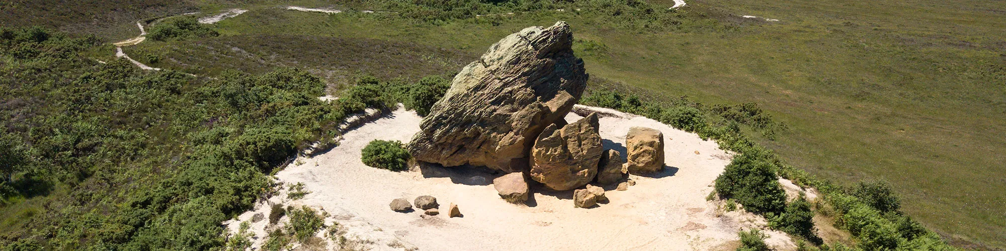
This 8.6-mile cycling route starts in Swanage and takes you across the wide open landscapes of Studland Heath. Along the way you’ll pass the striking landmark of Agglestone Rock, a huge sandstone block steeped in local legend, before looping back towards Swanage on a mix of heathland tracks and quiet lanes.
The route offers a good balance of scenery and challenge, with a combination of on-road and off-road sections. Expect some steeper hills that will test your legs, particularly on the return stretch. Surfaces vary from firm gravel to softer heathland paths, which can become muddy and slippery in wet winter weather, so a suitable bike and good tyres are recommended.
This ride is ideal if you’re looking for a short adventure with stunning Purbeck views, mixing natural beauty with a touch of local history.
Start:
Main Beach Car Park
Victoria Avenue
Swanage
BH19 1PW
OS Grid Ref: SZ 02667 79104
These routes have been recorded using a Garmin GPS unit. We cannot guarantee the accuracy of the available data files due to differences between GPS devices.
Route
Car Park
Elevation: 8 metres
OS Grid Reference: SZ 02706 79118
Lat, long: 50.61177, -1.96311
At the exit of the car park, turn right then left up Northbrook Road, continue past mini roundabout until you come to Ulwell Road
Junction
Elevation: 49 metres
OS Grid Reference: SZ 02231 80818
Lat, long: 50.62706, -1.96981
Turn left at junction and follow road until Y junction, turn left at junction and continue along road and up steep hill.
B3351 Junction
Elevation: 114 metres
OS Grid Reference: SZ 01237 81794
Lat, long: 50.63584, -1.98387
Turn right at top of hill and follow road past golf course
Start of Off Road
Elevation: 109 metres
OS Grid Reference: SZ 01708 81873
Lat, long: 50.63655, -1.97721
Turn left at layby with wooden gates and follow bridleway signs along side of golf course.
5 Double Gates
Elevation: 80 metres
OS Grid Reference: SZ 02086 82454
Lat, long: 50.64177, -1.97186
Continue straight ahead at double gates.
Junction
Elevation: 57 metres
OS Grid Reference: SZ 02321 82734
Lat, long: 50.64428, -1.96853
Turn left before Agglestone Rock and follow track turning right at next junction
Junction
Elevation: 30 metres
OS Grid Reference: SZ 02434 83275
Lat, long: 50.64915, -1.96694
Turn right onto wide track and continue down to river crossing and narrow bridge
Junction
Elevation: 27 metres
OS Grid Reference: SZ 03054 82978
Lat, long: 50.64648, -1.95817
Turn right onto track following bridleway signs
Gate
Elevation: 29 metres
OS Grid Reference: SZ 03032 82923
Lat, long: 50.64599, -1.95848
Turn right and go through gate and follow track up the side of the heathland past second set of gates until you come to the golf course on outgoing route
Junction
Elevation: 107 metres
OS Grid Reference: SZ 01790 82023
Lat, long: 50.63790, -1.97605
Turn left and follow track back to road and turn right at road towards Studland
Y Junction
Elevation: 79 metres
OS Grid Reference: SZ 02434 81959
Lat, long: 50.63732, -1.96694
Turn right and follow road down to Swanage, continue along road until you come to the clock tower with jetty on left
Shore Road and Victoria Avenue
Elevation: 4 metres
OS Grid Reference: SZ 03073 79141
Lat, long: 50.61198, -1.95793
Turn right onto Victoria Avenue and follow road back to start
Elevation Chart and Map
Move your mouse over the elevation line to view the location on the route map.
Walker & Cyclist Friendly Accommodation
Whether you’re exploring scenic trails, tackling longer routes, or simply enjoying a leisurely ride, choosing the right base makes all the difference. Below you’ll find details of some of the many local accommodation businesses that understands the needs of outdoor enthusiasts, helping you relax, recharge, and get ready for your next journey.