Studland To the Obelisk and Old Harry Walk
Walking Route
Type: Walk
Distance: 6.4 miles - 10.3km
Total Ascent: 895ft - 273m
![]() Starting location:
Starting location:
Middle Beach Car park
Beach Road
Studland
BH19 3AX
Grid Ref: SZ 03612 82838
Description:
A walk starting at Studland and walking across the edge of the heathland, heading across the golf course and returning via Ballard Down and Old Harry Rocks.
These routes have been recorded using a Garmin GPS unit. We cannot guarantee the accuracy of the available data files due to differences between GPS devices.
Route
1 - Start from Middle Beach Car Park in Studland - Exit the car park and turn left on Beach Road and then right on the footpath on the right side of the road marked Fort Henry.
02 - Fort Henry Footpath - Follow the footpath past Fort Henry until you come to Manor Road. This path offers views over Studland Bay to Old Harry Rocks.
03 - Manor Road - Turn right at Manor Road and then left onto a footpath on the left side of the road next to the car park entrance.
04 - Footpath to St Nicholas Church - At the footpath to St Nicholas Church, go through the gates and follow the path to the church yard, past the graves until you come to the west end of the church building and a footpath heading North/South.
05 - St Nicholas Church - At the west end of the church building,continue straight ahead along the narrow footpath until you come to School Lane.
06 - School Lane - At School Lane, turn right and follow the road up to the junction with Swanage Road and the village shop
07 Ferry Road Junction - At the cross roads, go straight ahead and onto Heath Green Road. Before the Village Hall on your left is a small lane heading South, turn left and follow this path behind the houses until it comes down to Heath Green Road again.
08 - Heath Green Road - At Heath Green Road, turn Left then continue along the road until you come to a rough track on the right marked Agglestone Road.
09 - Heath Green Road and Agglestone Road - Turn right into Agglestone Road and follow the rough track as it turns left behind the houses and continue until the end of the road and two footpath entrances.
10 - Gate - Continue straight ahead though the gate/entrance on the left side and continue straight ahead heading West along the path.
11 - Junction with Bridleway - At the T junction with the bridleway, continue straight ahead and follow the path until you come to a T junction heading to your left and right and the open golf course ahead.
12 - Bridleway junction - At the T junction, turn left and follow the rough track to a wooden gate and junction with the B3351
13 - B3351 Junction - At the junction turn left and follow the road for approx 45m, go across the road to a stile on the right side. Take care as this road is very busy during the summer months.
14 - Stile and Golf Course - At the wooden stile, go over the stile and follow the footpath heading south across the golf course , down to trees and continue south until you come to the stile and road.
15 - Ulwell Road Stile - At Ulwell Road, turn left and walk up the hill keeping on the grass verge until you come to a bus stop and wide track on the right side with a path heading East up the hill.
16 - Ulwell Road and Bridleway - Go across the road and through a gate, follow the wide path up the steep hill to the stone obelisk.
17 - Stone obelisk - At the stone obelisk, continue straight ahead and follow the footpath on the top of the hill heading east past 2 sets of gates until you come to a narrow section of path and small raised earthwork barrows.
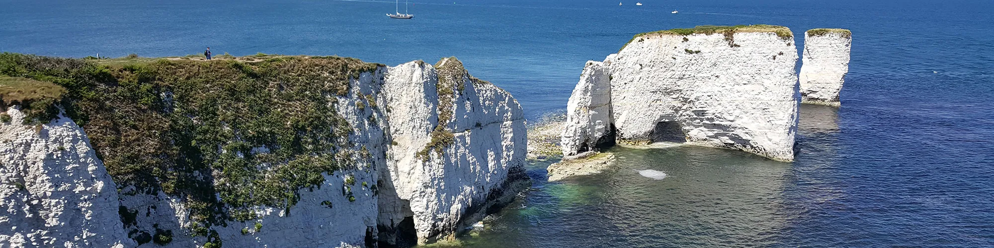
18 - Chalk narrow path and field - Continue though the narrow chalk path section and turn to your right following the rough track to a second gate, continue though the gate and follow the coast path along the top of the cliffs down the hill then left to the Foreland and Old Harry Rocks.
19 - The Foreland and Old Harry Rocks - At the Foreland turn left and follow the wide track heading West to Studland.
20 - Junction Manor Road and Watery Lane - At the junction with Manor Road and Watery Lane, turn right and continue up the hill past the pub and follow Manor Road to the junction with Beach Road.
21 - Manor Road Beach Road Junction - At the junction with Beach Road, turn right and continue along Beach Road back to the car park and start of the walk.
Elevation Chart and Map
Move your mouse over the elevation line to view the location on the route map.