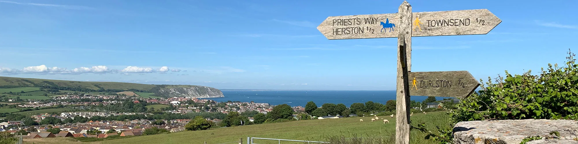
Durlston to Priest Way
Walking Route
Type: Walk
Distance: 4.0 miles
Total Ascent: 140m (approx)
![]() Starting location:
Starting location:
Durlston Country Park Car Park
OS Reference: SZ 03225 77353
Description:
This is a 4 mile walk around Durlston Country Park and the Townsend Nature Reserve which crosses part of Priests Way.The walk offers stunning views over the Isle of Purbeck, the Jurassic Coast and across to the Isle or Wight.
These routes have been recorded using a Garmin GPS unit. We cannot guarantee the accuracy of the available data files due to differences between GPS devices.
Route
1 - Start - Start from Car Park at Durlston Country park and follow tarmac path down back towards Swanage
2 - Gate - Go left at the rough track and cross the road going through stile and continue west across field to wooden gate
3 - Gate - At wooden gate go through gate and follow track to top-left corner of the field with second gate.
4 - Gate - At gate bear left up and across field to wooden gate. Can be muddy in winter.
5 - Gate - At wooden gate turn right and follow track down hill to stile/gate
6 - Stile / Gate - Go through gate and follow path down field to metal gate
7 - Metal Gate - Go through metal gate and follow track up hill and down until you come to a wooden gate on left side.
8 - Gate - Turn left at the wooden gate into the Townsend nature reserve.
9 - Wooden turn gate - When you reach the wooden gate at the far side of the Townsend nature reserve go through the gate onto the road a turn right down the hill.
10 - Metal gate - A short distance down the hill you will come to a metal gate on your left. Go through the gate into the caravan park and go right along the road. Follow the road as it goes left until you come to the third T-junction. Turn right down the hill and the and then left at the next junction. Continue straight ahead until you come to a cross roads where you go straight across. The road goes up a shallow hill before turning right, there should be a stile on your left a short distance down the hill.If you get lost in the caravan park keep heading in a westerly direction and you should come out on a road on the far side of the park which goes from the top of the park to the bottom. The stile is near the top end of this road.
11 - Wooden stile - Go through the stile and follow the wide path along the lower edge of the field above a caravan park.
12 - Metal Turn Gate - Cross the road and go up the hill a short distance until you come to a footpath on the right. Follow the footpath through the metal gate and across the field until you come to an abandoned stone quarry.
13 - Metal Gate and turn left - Go around the quarry building to the right and left through a metal gate and left up the steep stone track, following the sign post for Durlston.
14 - Gate - At the top of the hill go straight ahead through the gate and south across the field to the next gate.
15 - Gate - Go through the gate and follow the stone wall on your left down the hill.
16 - Turn left - When you reach the end of the stone wall turn left and follow the track along the top of the field. This track will be muddy in the winter.
17 - Broken wall - Go through the gap in the broken stone wall and follow the footpath west across the field towards Durlston Country Park.
18 - Wooden kissing gate - At the wooden kissing gate go right along the footpath for a few meters until you reach the top ridge of the hill and then turn left following the footpath until you reach the next stone wall.
19 - Stone stile - At the stone wall climb over the stone stile and bear left down across the field away from the sea and into the valley. The path will come to a t-junction at the base of the valley where you go east following the footpath until you reach a wooden gate,
20 - Wooden gate - At the wooden gate go straight ahead and follow the path up towards Durlston with the lighthouse on your right.
21 - Wooden kissing gate - At the wooden kissing gate continue east straight ahead until you reach the road and another wooden gate which may be open or closed depending on whether there are animals in the field.
22 - Tarmac Road - Follow the road east under the trees until you reach the car park and the end of your walk.
Elevation Chart and Map
Move your mouse over the elevation line to view the location on the route map.