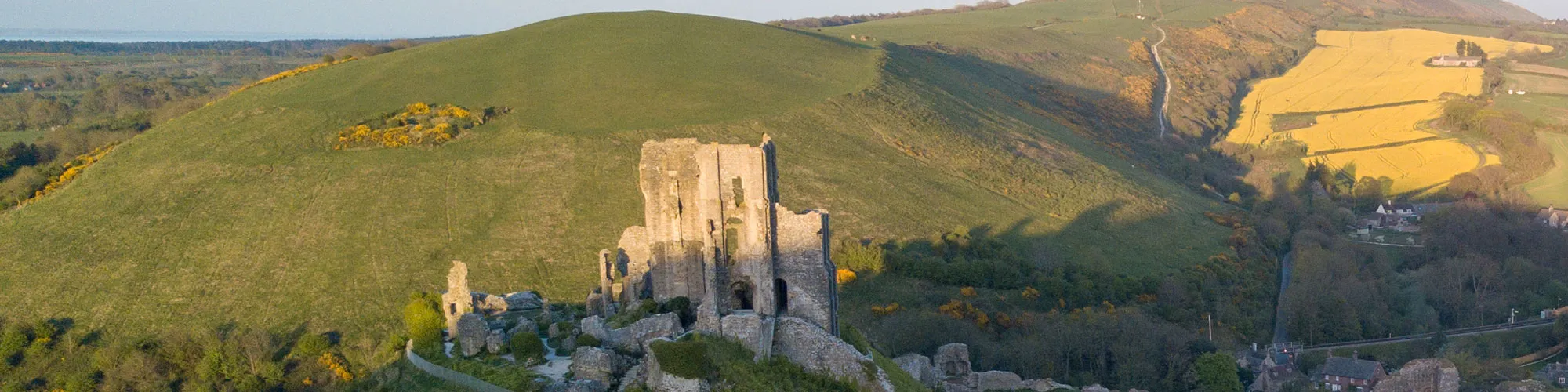
Rempstone Forest to Corfe Castle
Cycling Route
Type: Off Road Ride
Distance: 19 miles
Total Ascent: 140m (approx)
![]() Starting location:
Starting location:
Main Beach Car Park
Victoria Avenue
Swanage
BH19 1PW
OS Grid Ref: SZ 02667 79104
Description:
Swanage, Studland Heath , Rempstone Forest, Corfe Castle, back via Kingston , Langton or the Priests Way. Some steep climbs on and off road and open off road tracks.
These routes have been recorded using a Garmin GPS unit. We cannot guarantee the accuracy of the available data files due to differences between GPS devices.
Route
1 - Start of ride - Start at Victoria Avenue Car park, exit Car park,right then left up Northbrook Road
2 - Northbrook Road and Darkie Lane - At mini roundabout continue straight ahead up Darkie Lane and follow road to right past Y junction until you come to the main road T junction
3 - Ulwell Road and Darkie Lane - Turn left onto Ulwell Road
4 - Y Junction - Turn left at junction and proceed up steep hill.
5 - B3351 Junction - B3351 Junction - Turn right at top of hill and follow road past golf course until you come to a small clearing on your left with a wooden gate and 3 parking spaces.
6 - B3351 Parking Area and Gate - Turn left through gate at small parking area on left and continue SA for approx. 300 meters past open area of the golf course.
7 - Y Junction - Turn Left where Track splits off and follow track along the edge of the golf course
8 - Franks Tank - Follow signposts bridleway past edge of golf course and continue until you come to a wooden date next to a large metal water tank with”Franks Tank” written on the side. Through the gate and continue straight ahead
9 - Bridleway Junction - Turn right onto bridleway track and continue straight ahead
10 - Cross Roads - At cross roads, turn left onto tarmac road and continue to next cross road junction.
11 - Cross Roads - At junction continue straight ahead onto rough track, this track can be muddy in winter.
12 - Meaduss Lane - At junction with road, turn right and then left around corner and follow road until you come to a cross roads.
13 - Thrashers Lane - Cross the cross roads and go through narrow entrance and follow forest track to your right until you come to a road.
14 - Road - Continue straight ahead across the road onto rough track and wooden gate. Go through gate and continue on well defined track across open field, go straight ahead at next gate and continue down hill to small stone bridge with gate over a stream.
15 - Stone Bridge - Go over stone bridge and follow track through trees until you come to a wooden gate, go through gate and follow track to your left back to the tarmac road.
16 - Road - At tarmac road turn left and follow road until you go over a railway bridge and then come to a T junction
17 - T Junction - Turn right at junction and then left on roundabout following signs for Corfe Castle
18 - Village Square - At the village square turn right into West Street and follow road through village until you come to a cattle gird on the edge of Corfe Common
19 - Corfe Common - Go over cattle grid and follow road across the common until you come to a farm.
20 - Farm - Go through farm yard until gate at far right corner and then follow rough track up hill to Kingston village.
21 - Junction - Turn left into Kingston Village, a good place for a pub stop. Continue through village and go straight ahead at next junction next to pub. Follow hill up past church on your left.
22 - Worth Matravers Junction - Turn right at T junction and follow road down to Worth Matravers
23 - Square and Compass Pub - Turn left at Pub and follow road back out of village until you come to bridleway sign on your right.
24 - Gate - Turn right at gate and sign for Priests Way across open field and then onto Priests Way track.
25 - Priests Way - Continue SA and follow the Priests Way down towards Swanage for approx 1.5 miles
26 - Gate - At gate, turn sharp right and then SA at gates until you come to a old quarry works
27 - Gate - Turn left at gate and quarry and go down narrow track to second gate, go straight ahead at gate.
28 - Narrow Bridleway - Turn right and follow narrow bridleway to unmade road at back of houses.
29 - Priests Way - Turn left onto Priests road and follow road until you come to Gordon Hill
30 - Priests Road and Gordon Road - Turn left down Gordon Road, then right at bottom and follow road down hill, go SA at next junction
31 - Northbrook Road and Court Road - Turn left at railway bridge and follow road SA back to start.
Elevation Chart and Map
Move your mouse over the elevation line to view the location on the route map.