Norden Singletrack
Cycling Route
Type: Off Road Ride
Distance: 9 miles
Total Ascent: 140m (approx)
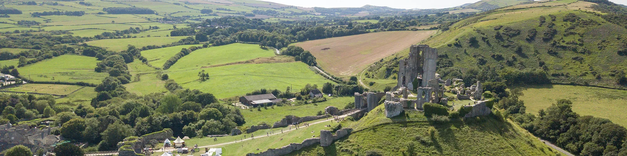
![]() Starting location:
Starting location:
National Trust Car Park, below Corfe Castle
OS Grid Ref: SY 95904 82464
Description:
A mixed ride around Corfe Castle which includes flat forest tracks, open fields, challenging climbs and fast and flowing single-track.
These routes have been recorded using a Garmin GPS unit. We cannot guarantee the accuracy of the available data files due to differences between GPS devices.
Route
1 - Start at NT car park - Exit the car park and turn left then right at T junction and follow road around the back of Corfe Castle
2 - Junction - After the stone bridge turn right at wooden gate and then left along track which goes up the side of the hill
3 - Y junction - Take the steep track to the right and past gate which is on the hill, continue along track on the top of the hill past gates until you come to a road
4 - Road - At the road go straight ahead and follow road down the hill and past quarry on left. Continue along road past camping site until you come to a sharp left corner. Bridleway is on the right of this corner.
5 - Start of Singletrack - Follow singletrack through woods and turn right at wooden bridge and continue along singletrack until you come to Norden camp site.
6 - Norden Camping Site - At camp site follow track through caravans and tents area and past farm yard to main road.
7 - A351 Junction - Turn left onto A351 and follow road over railway and take next right onto rough road.
8 - Junction New Line - Turn right onto rough track and follow past houses and turn right at bridleway sign. Continue along rough track to tarmac road.
9 - Junction - Continue straight ahead on road and follow until you come to a metal gate with stone pillars on each side. To the left of this gate is a sign post with wooden gates. Continue through wooden gates and follow track towards trees on right side.
10 - Wooden gate - At wooden gate, follow narrow track under trees until you come to a stone bridge with a wooden gate on far side.
11 - Stone bridge and gate - At gate continue across field following path and through next date into large field. Continue across path in field until you come to gate.
12 - Road - At road go straight ahead across the road and follow track through trees until you come to narrow gate at road.
13 - Road - Turn right onto narrow road and follow road South until you come to T junction.
14 - B3351 and Thrashers Lane - Turn right onto B3351 and follow road back to A351.
15 - A351 and B3351 - Turn right and follow A351 back to start. Caution very busy road in summer months.
Elevation Chart and Map
Move your mouse over the elevation line to view the location on the route map.